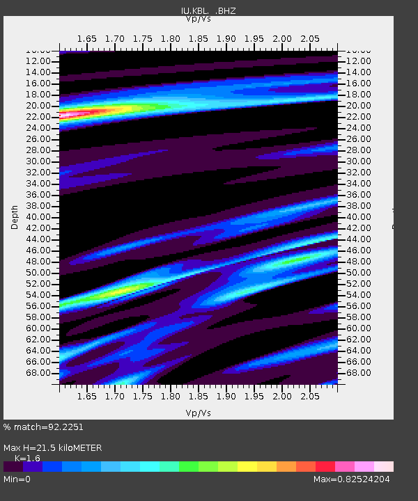
KBL Kabul, Afghanistan - Earthquake Result Viewer
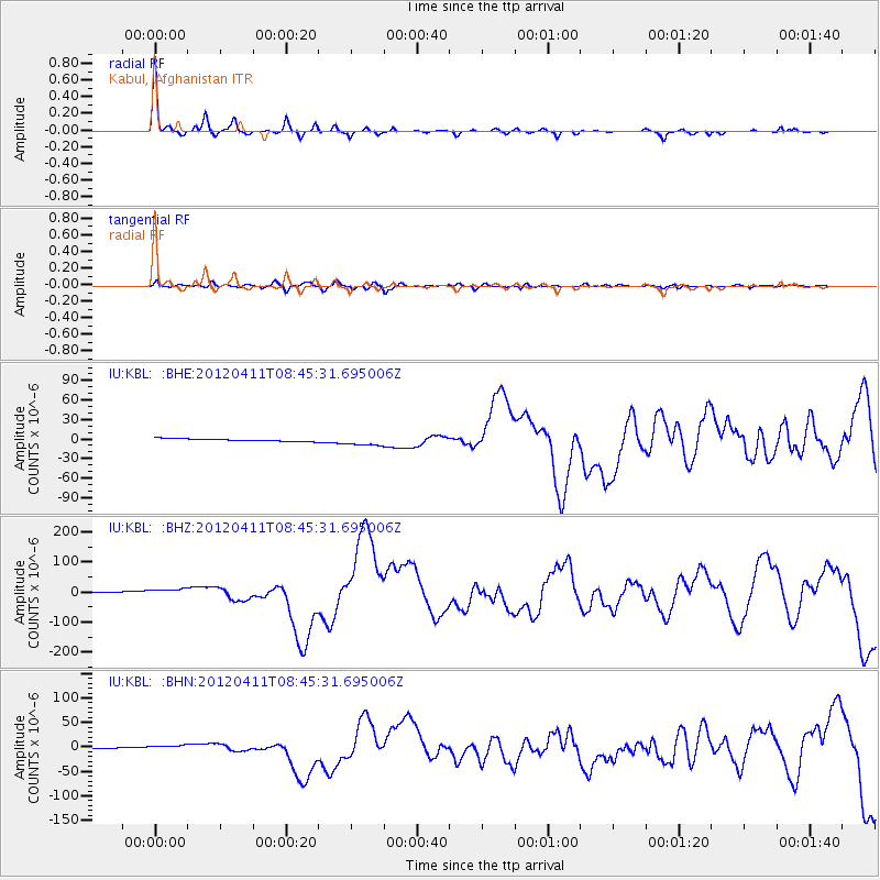
Earthquake location: Off W Coast Of Northern Sumatra
Earthquake latitude/longitude: 2.3/93.1
Earthquake time(UTC): 2012/04/11 (102) 08:38:36 GMT
Earthquake Depth: 20 km
Earthquake Magnitude: 7.4 MB, 8.5 MS, 8.6 MW, 8.6 MW
Earthquake Catalog/Contributor: WHDF/NEIC
Network: IU Global Seismograph Network (GSN - IRIS/USGS)
Station: KBL Kabul, Afghanistan
Lat/Lon: 34.54 N/69.04 E
Elevation: 1920 m
Distance: 39.1 deg
Az: 327.798 deg
Baz: 139.831 deg
Ray Param: 0.07516021
Estimated Moho Depth: 21.5 km
Estimated Crust Vp/Vs: 1.60
Assumed Crust Vp: 6.641 km/s
Estimated Crust Vs: 4.15 km/s
Estimated Crust Poisson's Ratio: 0.18
Radial Match: 92.2251 %
Radial Bump: 212
Transverse Match: 65.5438 %
Transverse Bump: 400
SOD ConfigId: 446234
Insert Time: 2012-07-04 09:23:24.629 +0000
GWidth: 2.5
Max Bumps: 400
Tol: 0.001

Signal To Noise

ChannelStoNSTALTA
IU:KBL: :BHZ:20120411T08:45:31.695006Z4.4925571.3937742E-53.1024074E-6
IU:KBL: :BHN:20120411T08:45:31.695006Z3.72105887.4107643E-61.991574E-6
IU:KBL: :BHE:20120411T08:45:31.695006Z3.72333317.2309713E-61.9420693E-6
Arrivals
Ps2.1 SECOND
PpPs7.7 SECOND
PsPs/PpSs9.8 SECOND