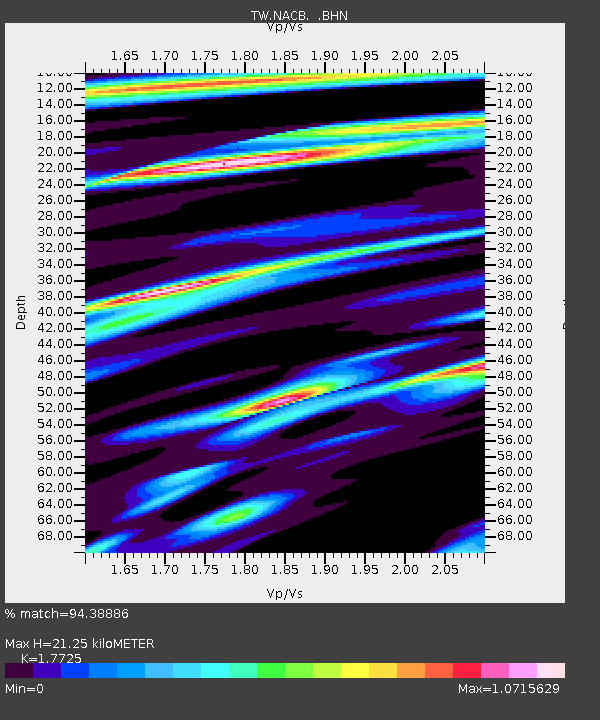
NACB NING-AN-CHIAO - Earthquake Result Viewer

Earthquake location: Off W Coast Of Northern Sumatra
Earthquake latitude/longitude: 2.3/93.1
Earthquake time(UTC): 2012/04/11 (102) 08:38:36 GMT
Earthquake Depth: 20 km
Earthquake Magnitude: 7.4 MB, 8.5 MS, 8.6 MW, 8.6 MW
Earthquake Catalog/Contributor: WHDF/NEIC
Network: TW Broadband Array in Taiwan for Seismology
Station: NACB NING-AN-CHIAO
Lat/Lon: 24.17 N/121.59 E
Elevation: 130 m
Distance: 35.1 deg
Az: 49.353 deg
Baz: 236.105 deg
Ray Param: 0.07737747
Estimated Moho Depth: 21.25 km
Estimated Crust Vp/Vs: 1.77
Assumed Crust Vp: 6.289 km/s
Estimated Crust Vs: 3.548 km/s
Estimated Crust Poisson's Ratio: 0.27
Radial Match: 94.38886 %
Radial Bump: 400
Transverse Match: 85.77055 %
Transverse Bump: 400
SOD ConfigId: 446234
Insert Time: 2012-07-04 09:26:16.828 +0000
GWidth: 2.5
Max Bumps: 400
Tol: 0.001

Signal To Noise

ChannelStoNSTALTA
TW:NACB: :BHZ:20120411T08:44:57.869994Z6.8550219.415789E-61.3735608E-6
TW:NACB: :BHN:20120411T08:44:57.869994Z9.9533094.372547E-64.3930592E-7
TW:NACB: :BHE:20120411T08:44:57.869994Z7.82940635.6996637E-67.279816E-7
Arrivals
Ps2.8 SECOND
PpPs8.7 SECOND
PsPs/PpSs12 SECOND