You are here: Home > Network List > G - GEOSCOPE Stations List
> Station INU Inuyama, Japan > Earthquake Result Viewer
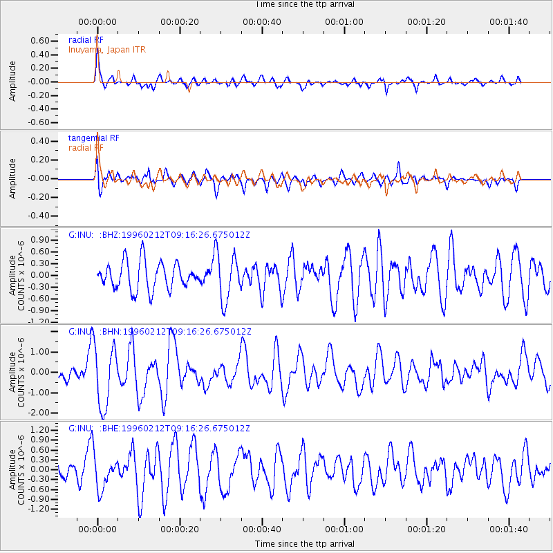
INU Inuyama, Japan - Earthquake Result Viewer
*The percent match for this event was below the threshold and hence no stack was calculated.
| Earthquake location: |
South Of Sumbawa, Indonesia |
| Earthquake latitude/longitude: |
-11.2/118.7 |
| Earthquake time(UTC): |
1996/02/12 (043) 09:08:10 GMT |
| Earthquake Depth: |
33 km |
| Earthquake Magnitude: |
5.8 MB, 5.8 MS, 6.1 UNKNOWN, 6.0 MW |
| Earthquake Catalog/Contributor: |
WHDF/NEIC |
|
| Network: |
G GEOSCOPE |
| Station: |
INU Inuyama, Japan |
| Lat/Lon: |
35.35 N/137.03 E |
| Elevation: |
132 m |
|
| Distance: |
49.4 deg |
| Az: |
19.829 deg |
| Baz: |
204.03 deg |
| Ray Param: |
$rayparam |
*The percent match for this event was below the threshold and hence was not used in the summary stack. |
|
| Radial Match: |
71.780945 % |
| Radial Bump: |
382 |
| Transverse Match: |
63.59066 % |
| Transverse Bump: |
400 |
| SOD ConfigId: |
4480 |
| Insert Time: |
2010-02-26 23:27:18.510 +0000 |
| GWidth: |
2.5 |
| Max Bumps: |
400 |
| Tol: |
0.001 |
|
Signal To Noise
| Channel | StoN | STA | LTA |
| G:INU: :BHN:19960212T09:16:26.675012Z | 3.96645 | 1.4863117E-6 | 3.747209E-7 |
| G:INU: :BHE:19960212T09:16:26.675012Z | 1.1618884 | 4.6773513E-7 | 4.025646E-7 |
| G:INU: :BHZ:19960212T09:16:26.675012Z | 1.6633857 | 5.8034584E-7 | 3.4889433E-7 |
| Arrivals |
| Ps | |
| PpPs | |
| PsPs/PpSs | |


