You are here: Home > Network List > TA - USArray Transportable Network (new EarthScope stations) Stations List
> Station P38A Dawn, MO, USA > Earthquake Result Viewer
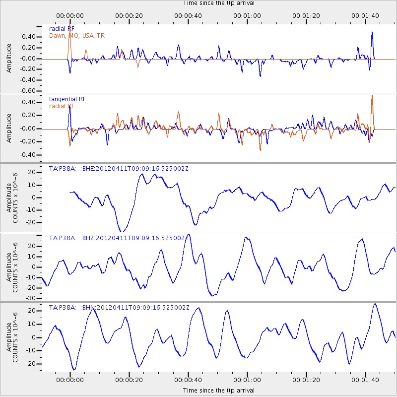
P38A Dawn, MO, USA - Earthquake Result Viewer
*The percent match for this event was below the threshold and hence no stack was calculated.
| Earthquake location: |
Andreanof Islands, Aleutian Is. |
| Earthquake latitude/longitude: |
51.4/-176.1 |
| Earthquake time(UTC): |
2012/04/11 (102) 09:00:09 GMT |
| Earthquake Depth: |
21 km |
| Earthquake Magnitude: |
5.5 MB, 5.4 ML |
| Earthquake Catalog/Contributor: |
WHDF/NEIC |
|
| Network: |
TA USArray Transportable Network (new EarthScope stations) |
| Station: |
P38A Dawn, MO, USA |
| Lat/Lon: |
39.62 N/93.53 W |
| Elevation: |
248 m |
|
| Distance: |
56.1 deg |
| Az: |
67.299 deg |
| Baz: |
311.509 deg |
| Ray Param: |
$rayparam |
*The percent match for this event was below the threshold and hence was not used in the summary stack. |
|
| Radial Match: |
42.91405 % |
| Radial Bump: |
400 |
| Transverse Match: |
52.35332 % |
| Transverse Bump: |
400 |
| SOD ConfigId: |
446234 |
| Insert Time: |
2012-07-04 09:47:43.955 +0000 |
| GWidth: |
2.5 |
| Max Bumps: |
400 |
| Tol: |
0.001 |
|
Signal To Noise
| Channel | StoN | STA | LTA |
| TA:P38A: :BHZ:20120411T09:09:16.525002Z | 0.36166236 | 3.9125766E-6 | 1.0818313E-5 |
| TA:P38A: :BHN:20120411T09:09:16.525002Z | 1.9267102 | 1.5137402E-5 | 7.856605E-6 |
| TA:P38A: :BHE:20120411T09:09:16.525002Z | 1.5961463 | 1.7888564E-5 | 1.1207346E-5 |
| Arrivals |
| Ps | |
| PpPs | |
| PsPs/PpSs | |


