You are here: Home > Network List > G - GEOSCOPE Stations List
> Station INU Inuyama, Japan > Earthquake Result Viewer
INU Inuyama, Japan - Earthquake Result Viewer
*The percent match for this event was below the threshold and hence no stack was calculated.
| Earthquake location: |
Banda Sea |
| Earthquake latitude/longitude: |
-7.4/128.1 |
| Earthquake time(UTC): |
1994/06/16 (167) 10:12:48 GMT |
| Earthquake Depth: |
119 km |
| Earthquake Magnitude: |
5.8 MB, 6.0 UNKNOWN, 5.9 MW |
| Earthquake Catalog/Contributor: |
WHDF/NEIC |
|
| Network: |
G GEOSCOPE |
| Station: |
INU Inuyama, Japan |
| Lat/Lon: |
35.35 N/137.03 E |
| Elevation: |
132 m |
|
| Distance: |
43.3 deg |
| Az: |
10.633 deg |
| Baz: |
192.937 deg |
| Ray Param: |
$rayparam |
*The percent match for this event was below the threshold and hence was not used in the summary stack. |
|
| Radial Match: |
73.76631 % |
| Radial Bump: |
400 |
| Transverse Match: |
64.45888 % |
| Transverse Bump: |
400 |
| SOD ConfigId: |
4480 |
| Insert Time: |
2010-02-26 23:27:24.916 +0000 |
| GWidth: |
2.5 |
| Max Bumps: |
400 |
| Tol: |
0.001 |
|
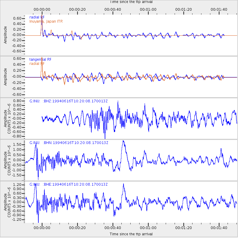
Signal To Noise
| Channel | StoN | STA | LTA |
| G:INU: :BHN:19940616T10:20:08.170013Z | 3.533824 | 4.86066E-7 | 1.3754676E-7 |
| G:INU: :BHE:19940616T10:20:08.170013Z | 1.6609904 | 3.3278758E-7 | 2.003549E-7 |
| G:INU: :BHZ:19940616T10:20:08.170013Z | 1.991426 | 2.885925E-7 | 1.4491751E-7 |
| Arrivals |
| Ps | |
| PpPs | |
| PsPs/PpSs | |


