You are here: Home > Network List > TA - USArray Transportable Network (new EarthScope stations) Stations List
> Station Y46A Houston, MS, USA > Earthquake Result Viewer
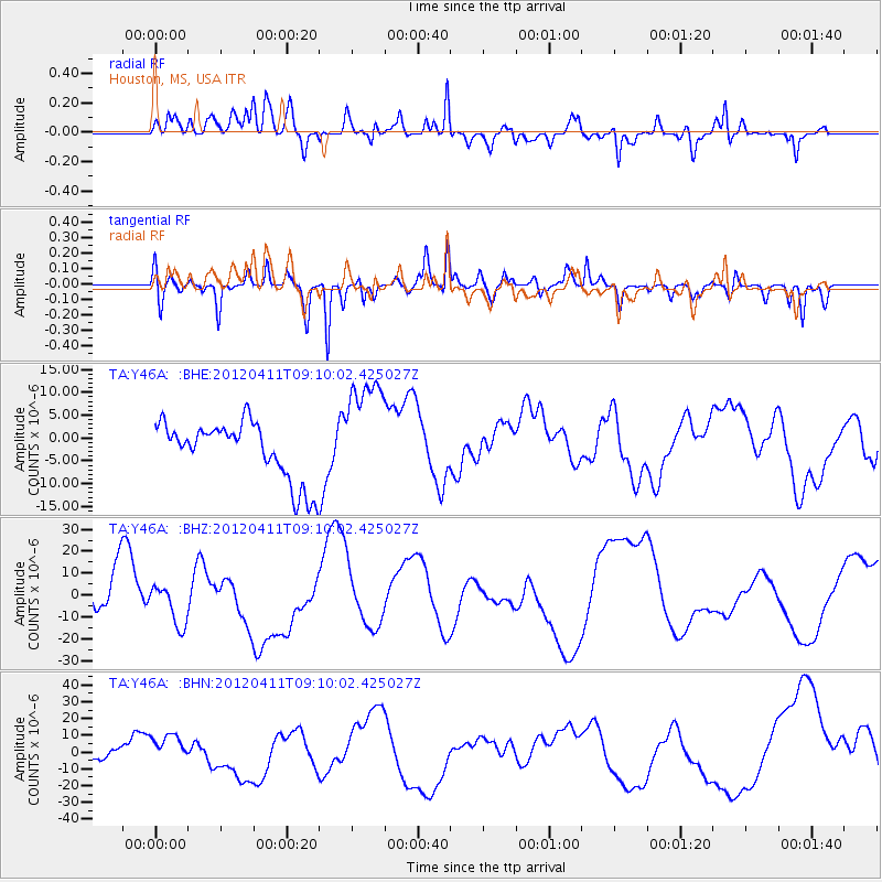
Y46A Houston, MS, USA - Earthquake Result Viewer
*The percent match for this event was below the threshold and hence no stack was calculated.
| Earthquake location: |
Andreanof Islands, Aleutian Is. |
| Earthquake latitude/longitude: |
51.4/-176.1 |
| Earthquake time(UTC): |
2012/04/11 (102) 09:00:09 GMT |
| Earthquake Depth: |
21 km |
| Earthquake Magnitude: |
5.5 MB, 5.4 ML |
| Earthquake Catalog/Contributor: |
WHDF/NEIC |
|
| Network: |
TA USArray Transportable Network (new EarthScope stations) |
| Station: |
Y46A Houston, MS, USA |
| Lat/Lon: |
33.88 N/88.86 W |
| Elevation: |
109 m |
|
| Distance: |
62.8 deg |
| Az: |
69.138 deg |
| Baz: |
315.235 deg |
| Ray Param: |
$rayparam |
*The percent match for this event was below the threshold and hence was not used in the summary stack. |
|
| Radial Match: |
69.96547 % |
| Radial Bump: |
400 |
| Transverse Match: |
75.17607 % |
| Transverse Bump: |
373 |
| SOD ConfigId: |
446234 |
| Insert Time: |
2012-07-04 09:50:00.058 +0000 |
| GWidth: |
2.5 |
| Max Bumps: |
400 |
| Tol: |
0.001 |
|
Signal To Noise
| Channel | StoN | STA | LTA |
| TA:Y46A: :BHZ:20120411T09:10:02.425027Z | 0.92959774 | 9.548302E-6 | 1.0271434E-5 |
| TA:Y46A: :BHN:20120411T09:10:02.425027Z | 1.6804731 | 1.0775665E-5 | 6.412281E-6 |
| TA:Y46A: :BHE:20120411T09:10:02.425027Z | 1.9384093 | 1.2250585E-5 | 6.319917E-6 |
| Arrivals |
| Ps | |
| PpPs | |
| PsPs/PpSs | |


