You are here: Home > Network List > G - GEOSCOPE Stations List
> Station INU Inuyama, Japan > Earthquake Result Viewer
INU Inuyama, Japan - Earthquake Result Viewer
*The percent match for this event was below the threshold and hence no stack was calculated.
| Earthquake location: |
Solomon Islands |
| Earthquake latitude/longitude: |
-7.2/155.5 |
| Earthquake time(UTC): |
1996/10/14 (288) 00:07:58 GMT |
| Earthquake Depth: |
33 km |
| Earthquake Magnitude: |
5.8 MS, 5.4 MB |
| Earthquake Catalog/Contributor: |
WHDF/NEIC |
|
| Network: |
G GEOSCOPE |
| Station: |
INU Inuyama, Japan |
| Lat/Lon: |
35.35 N/137.03 E |
| Elevation: |
132 m |
|
| Distance: |
45.8 deg |
| Az: |
338.831 deg |
| Baz: |
154.005 deg |
| Ray Param: |
$rayparam |
*The percent match for this event was below the threshold and hence was not used in the summary stack. |
|
| Radial Match: |
66.183586 % |
| Radial Bump: |
400 |
| Transverse Match: |
51.80057 % |
| Transverse Bump: |
400 |
| SOD ConfigId: |
4480 |
| Insert Time: |
2010-02-26 23:27:25.578 +0000 |
| GWidth: |
2.5 |
| Max Bumps: |
400 |
| Tol: |
0.001 |
|
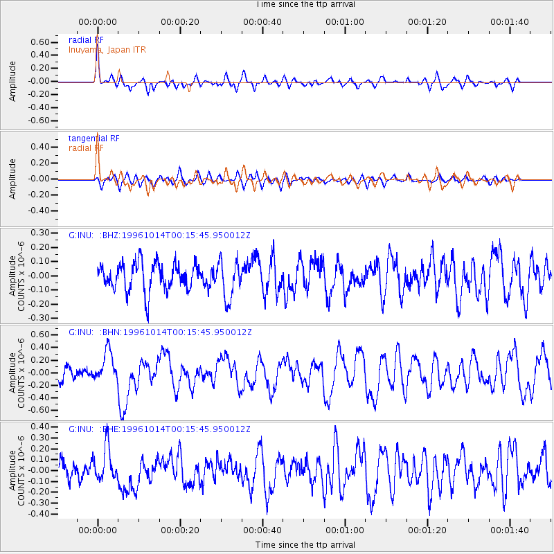
Signal To Noise
| Channel | StoN | STA | LTA |
| G:INU: :BHN:19961014T00:15:45.950012Z | 1.8315848 | 2.5380166E-7 | 1.3856942E-7 |
| G:INU: :BHE:19961014T00:15:45.950012Z | 1.2836066 | 1.6068508E-7 | 1.251825E-7 |
| G:INU: :BHZ:19961014T00:15:45.950012Z | 1.4072461 | 1.3593403E-7 | 9.659578E-8 |
| Arrivals |
| Ps | |
| PpPs | |
| PsPs/PpSs | |


