You are here: Home > Network List > TA - USArray Transportable Network (new EarthScope stations) Stations List
> Station W42A Bald Knob, AR, USA > Earthquake Result Viewer
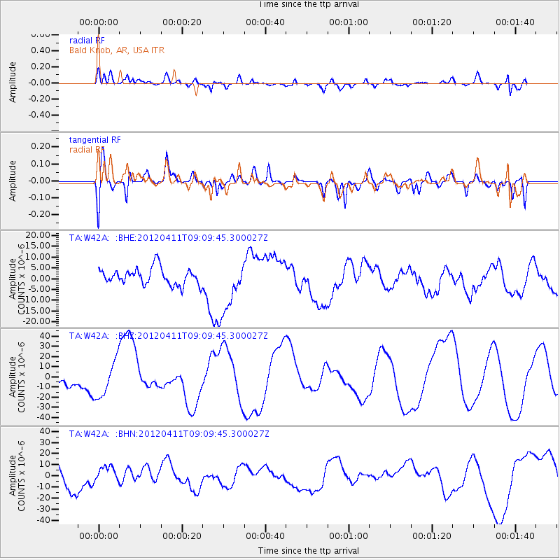
W42A Bald Knob, AR, USA - Earthquake Result Viewer
*The percent match for this event was below the threshold and hence no stack was calculated.
| Earthquake location: |
Andreanof Islands, Aleutian Is. |
| Earthquake latitude/longitude: |
51.4/-176.1 |
| Earthquake time(UTC): |
2012/04/11 (102) 09:00:09 GMT |
| Earthquake Depth: |
21 km |
| Earthquake Magnitude: |
5.5 MB, 5.4 ML |
| Earthquake Catalog/Contributor: |
WHDF/NEIC |
|
| Network: |
TA USArray Transportable Network (new EarthScope stations) |
| Station: |
W42A Bald Knob, AR, USA |
| Lat/Lon: |
35.27 N/91.52 W |
| Elevation: |
71 m |
|
| Distance: |
60.2 deg |
| Az: |
69.773 deg |
| Baz: |
314.032 deg |
| Ray Param: |
$rayparam |
*The percent match for this event was below the threshold and hence was not used in the summary stack. |
|
| Radial Match: |
53.41133 % |
| Radial Bump: |
400 |
| Transverse Match: |
38.491837 % |
| Transverse Bump: |
400 |
| SOD ConfigId: |
446234 |
| Insert Time: |
2012-07-04 09:51:48.238 +0000 |
| GWidth: |
2.5 |
| Max Bumps: |
400 |
| Tol: |
0.001 |
|
Signal To Noise
| Channel | StoN | STA | LTA |
| TA:W42A: :BHZ:20120411T09:09:45.300027Z | 1.5721601 | 1.7844952E-5 | 1.1350595E-5 |
| TA:W42A: :BHN:20120411T09:09:45.300027Z | 0.57116175 | 7.5660814E-6 | 1.3246828E-5 |
| TA:W42A: :BHE:20120411T09:09:45.300027Z | 3.144834 | 1.2235042E-5 | 3.890521E-6 |
| Arrivals |
| Ps | |
| PpPs | |
| PsPs/PpSs | |


