You are here: Home > Network List > G - GEOSCOPE Stations List
> Station INU Inuyama, Japan > Earthquake Result Viewer
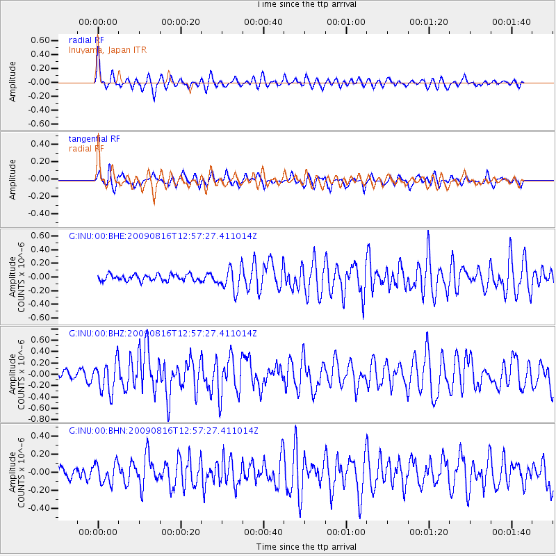
INU Inuyama, Japan - Earthquake Result Viewer
*The percent match for this event was below the threshold and hence no stack was calculated.
| Earthquake location: |
Southern Sumatra, Indonesia |
| Earthquake latitude/longitude: |
-1.4/99.4 |
| Earthquake time(UTC): |
2009/08/16 (228) 12:49:00 GMT |
| Earthquake Depth: |
21 km |
| Earthquake Magnitude: |
6.0 MB, 5.6 MS, 5.8 MW, 5.7 MW |
| Earthquake Catalog/Contributor: |
WHDF/NEIC |
|
| Network: |
G GEOSCOPE |
| Station: |
INU Inuyama, Japan |
| Lat/Lon: |
35.35 N/137.03 E |
| Elevation: |
132 m |
|
| Distance: |
50.7 deg |
| Az: |
40.109 deg |
| Baz: |
231.986 deg |
| Ray Param: |
$rayparam |
*The percent match for this event was below the threshold and hence was not used in the summary stack. |
|
| Radial Match: |
67.45896 % |
| Radial Bump: |
400 |
| Transverse Match: |
64.54148 % |
| Transverse Bump: |
389 |
| SOD ConfigId: |
2622 |
| Insert Time: |
2010-02-26 23:27:45.069 +0000 |
| GWidth: |
2.5 |
| Max Bumps: |
400 |
| Tol: |
0.001 |
|
Signal To Noise
| Channel | StoN | STA | LTA |
| G:INU:00:BHZ:20090816T12:57:27.411014Z | 3.601178 | 2.8018493E-7 | 7.780369E-8 |
| G:INU:00:BHN:20090816T12:57:27.411014Z | 2.0168548 | 1.1554538E-7 | 5.7289885E-8 |
| G:INU:00:BHE:20090816T12:57:27.411014Z | 3.871828 | 1.7598981E-7 | 4.5453934E-8 |
| Arrivals |
| Ps | |
| PpPs | |
| PsPs/PpSs | |


