You are here: Home > Network List > TA - USArray Transportable Network (new EarthScope stations) Stations List
> Station N59A State Game Land 141, Hazleton, PA, USA > Earthquake Result Viewer
N59A State Game Land 141, Hazleton, PA, USA - Earthquake Result Viewer
| Earthquake location: |
Off Coast Of Oregon |
| Earthquake latitude/longitude: |
43.6/-127.6 |
| Earthquake time(UTC): |
2012/04/11 (102) 22:41:46 GMT |
| Earthquake Depth: |
8.0 km |
| Earthquake Magnitude: |
5.8 MB, 5.9 MS, 6.0 MW |
| Earthquake Catalog/Contributor: |
WHDF/NEIC |
|
| Network: |
TA USArray Transportable Network (new EarthScope stations) |
| Station: |
N59A State Game Land 141, Hazleton, PA, USA |
| Lat/Lon: |
40.92 N/75.77 W |
| Elevation: |
508 m |
|
| Distance: |
38.0 deg |
| Az: |
75.637 deg |
| Baz: |
291.735 deg |
| Ray Param: |
0.075833976 |
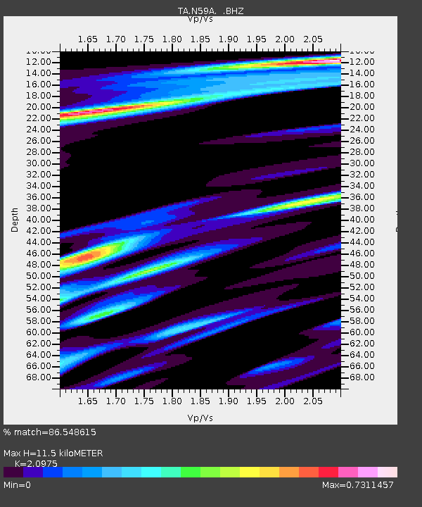
| Estimated Moho Depth: |
11.5 km |
| Estimated Crust Vp/Vs: |
2.10 |
| Assumed Crust Vp: |
6.283 km/s |
| Estimated Crust Vs: |
2.996 km/s |
| Estimated Crust Poisson's Ratio: |
0.35 |
|
| Radial Match: |
86.548615 % |
| Radial Bump: |
400 |
| Transverse Match: |
55.740437 % |
| Transverse Bump: |
400 |
| SOD ConfigId: |
446234 |
| Insert Time: |
2012-07-04 10:37:49.041 +0000 |
| GWidth: |
2.5 |
| Max Bumps: |
400 |
| Tol: |
0.001 |
|
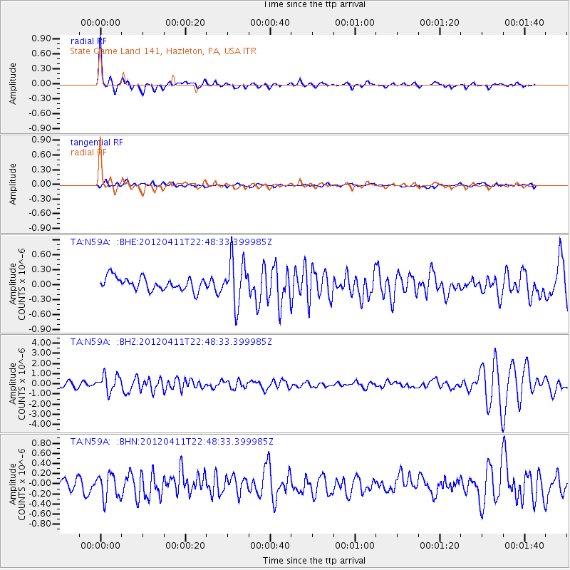
Signal To Noise
| Channel | StoN | STA | LTA |
| TA:N59A: :BHZ:20120411T22:48:33.399985Z | 3.680911 | 8.4080364E-7 | 2.2842269E-7 |
| TA:N59A: :BHN:20120411T22:48:33.399985Z | 1.595982 | 2.529537E-7 | 1.5849409E-7 |
| TA:N59A: :BHE:20120411T22:48:33.399985Z | 3.555451 | 4.574749E-7 | 1.286686E-7 |
| Arrivals |
| Ps | 2.1 SECOND |
| PpPs | 5.3 SECOND |
| PsPs/PpSs | 7.5 SECOND |


