You are here: Home > Network List > TA - USArray Transportable Network (new EarthScope stations) Stations List
> Station 148A Greensboro, AL, USA > Earthquake Result Viewer
148A Greensboro, AL, USA - Earthquake Result Viewer
| Earthquake location: |
Off Coast Of Oregon |
| Earthquake latitude/longitude: |
43.6/-127.6 |
| Earthquake time(UTC): |
2012/04/11 (102) 22:41:46 GMT |
| Earthquake Depth: |
8.0 km |
| Earthquake Magnitude: |
5.8 MB, 5.9 MS, 6.0 MW |
| Earthquake Catalog/Contributor: |
WHDF/NEIC |
|
| Network: |
TA USArray Transportable Network (new EarthScope stations) |
| Station: |
148A Greensboro, AL, USA |
| Lat/Lon: |
32.65 N/87.57 W |
| Elevation: |
63 m |
|
| Distance: |
33.1 deg |
| Az: |
95.616 deg |
| Baz: |
300.995 deg |
| Ray Param: |
0.07838199 |
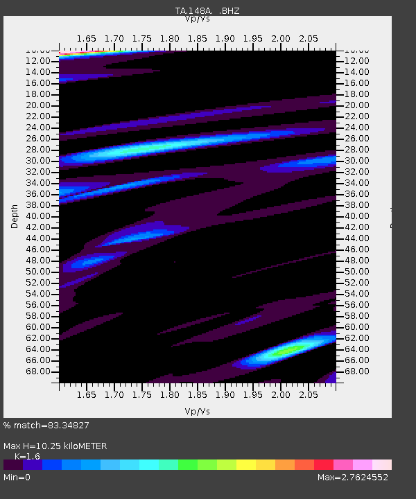
| Estimated Moho Depth: |
10.25 km |
| Estimated Crust Vp/Vs: |
1.60 |
| Assumed Crust Vp: |
6.565 km/s |
| Estimated Crust Vs: |
4.103 km/s |
| Estimated Crust Poisson's Ratio: |
0.18 |
|
| Radial Match: |
83.34827 % |
| Radial Bump: |
400 |
| Transverse Match: |
67.51953 % |
| Transverse Bump: |
400 |
| SOD ConfigId: |
446234 |
| Insert Time: |
2012-07-04 10:45:43.570 +0000 |
| GWidth: |
2.5 |
| Max Bumps: |
400 |
| Tol: |
0.001 |
|

Signal To Noise
| Channel | StoN | STA | LTA |
| TA:148A: :BHZ:20120411T22:47:51.325004Z | 9.526149 | 1.4990194E-6 | 1.5735839E-7 |
| TA:148A: :BHN:20120411T22:47:51.325004Z | 2.2645342 | 7.6115873E-7 | 3.3612156E-7 |
| TA:148A: :BHE:20120411T22:47:51.325004Z | 2.57163 | 7.514655E-7 | 2.9221368E-7 |
| Arrivals |
| Ps | 1.0 SECOND |
| PpPs | 3.7 SECOND |
| PsPs/PpSs | 4.7 SECOND |


