You are here: Home > Network List > G - GEOSCOPE Stations List
> Station INU Inuyama, Japan > Earthquake Result Viewer
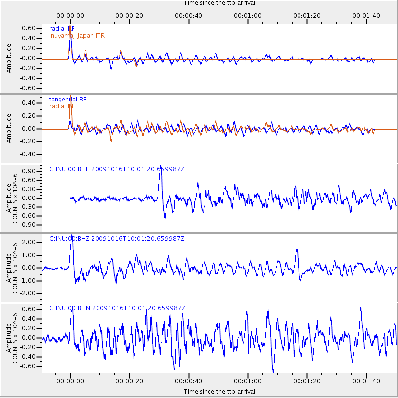
INU Inuyama, Japan - Earthquake Result Viewer
*The percent match for this event was below the threshold and hence no stack was calculated.
| Earthquake location: |
Sunda Strait, Indonesia |
| Earthquake latitude/longitude: |
-6.5/105.2 |
| Earthquake time(UTC): |
2009/10/16 (289) 09:52:50 GMT |
| Earthquake Depth: |
38 km |
| Earthquake Magnitude: |
5.9 MB, 5.8 MS, 6.1 MW, 6.1 MW |
| Earthquake Catalog/Contributor: |
WHDF/NEIC |
|
| Network: |
G GEOSCOPE |
| Station: |
INU Inuyama, Japan |
| Lat/Lon: |
35.35 N/137.03 E |
| Elevation: |
132 m |
|
| Distance: |
51.3 deg |
| Az: |
33.504 deg |
| Baz: |
222.139 deg |
| Ray Param: |
$rayparam |
*The percent match for this event was below the threshold and hence was not used in the summary stack. |
|
| Radial Match: |
78.7847 % |
| Radial Bump: |
400 |
| Transverse Match: |
69.11305 % |
| Transverse Bump: |
400 |
| SOD ConfigId: |
2622 |
| Insert Time: |
2010-02-26 23:28:05.039 +0000 |
| GWidth: |
2.5 |
| Max Bumps: |
400 |
| Tol: |
0.001 |
|
Signal To Noise
| Channel | StoN | STA | LTA |
| G:INU:00:BHZ:20091016T10:01:20.659987Z | 15.669153 | 1.1135818E-6 | 7.1068406E-8 |
| G:INU:00:BHN:20091016T10:01:20.659987Z | 4.7537737 | 2.82977E-7 | 5.9526815E-8 |
| G:INU:00:BHE:20091016T10:01:20.659987Z | 11.349443 | 4.7882577E-7 | 4.2189363E-8 |
| Arrivals |
| Ps | |
| PpPs | |
| PsPs/PpSs | |


