You are here: Home > Network List > G - GEOSCOPE Stations List
> Station CLF Chambon la Foret observatory, France > Earthquake Result Viewer
CLF Chambon la Foret observatory, France - Earthquake Result Viewer
| Earthquake location: |
Michoacan, Mexico |
| Earthquake latitude/longitude: |
18.2/-102.7 |
| Earthquake time(UTC): |
2012/04/11 (102) 22:55:10 GMT |
| Earthquake Depth: |
20 km |
| Earthquake Magnitude: |
5.8 MB, 6.7 MS, 6.5 MW, 6.7 MW |
| Earthquake Catalog/Contributor: |
WHDF/NEIC |
|
| Network: |
G GEOSCOPE |
| Station: |
CLF Chambon la Foret observatory, France |
| Lat/Lon: |
48.03 N/2.26 E |
| Elevation: |
145 m |
|
| Distance: |
86.2 deg |
| Az: |
40.539 deg |
| Baz: |
293.035 deg |
| Ray Param: |
0.044187862 |
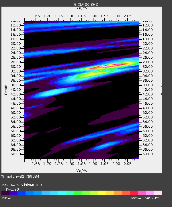
| Estimated Moho Depth: |
29.5 km |
| Estimated Crust Vp/Vs: |
1.96 |
| Assumed Crust Vp: |
6.12 km/s |
| Estimated Crust Vs: |
3.122 km/s |
| Estimated Crust Poisson's Ratio: |
0.32 |
|
| Radial Match: |
82.769684 % |
| Radial Bump: |
400 |
| Transverse Match: |
77.55867 % |
| Transverse Bump: |
400 |
| SOD ConfigId: |
446234 |
| Insert Time: |
2012-07-04 10:57:50.473 +0000 |
| GWidth: |
2.5 |
| Max Bumps: |
400 |
| Tol: |
0.001 |
|
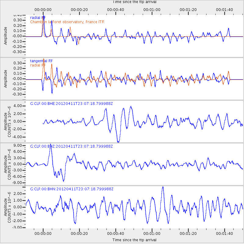
Signal To Noise
| Channel | StoN | STA | LTA |
| G:CLF:00:BHZ:20120411T23:07:18.799988Z | 6.8272166 | 4.0955583E-6 | 5.9988696E-7 |
| G:CLF:00:BHN:20120411T23:07:18.799988Z | 0.41675526 | 3.1314343E-7 | 7.5138445E-7 |
| G:CLF:00:BHE:20120411T23:07:18.799988Z | 3.8805413 | 1.4455504E-6 | 3.7251257E-7 |
| Arrivals |
| Ps | 4.7 SECOND |
| PpPs | 14 SECOND |
| PsPs/PpSs | 19 SECOND |


