You are here: Home > Network List > G - GEOSCOPE Stations List
> Station IVI Ivittuut, Greenland > Earthquake Result Viewer
IVI Ivittuut, Greenland - Earthquake Result Viewer
| Earthquake location: |
Michoacan, Mexico |
| Earthquake latitude/longitude: |
18.2/-102.7 |
| Earthquake time(UTC): |
2012/04/11 (102) 22:55:10 GMT |
| Earthquake Depth: |
20 km |
| Earthquake Magnitude: |
5.8 MB, 6.7 MS, 6.5 MW, 6.7 MW |
| Earthquake Catalog/Contributor: |
WHDF/NEIC |
|
| Network: |
G GEOSCOPE |
| Station: |
IVI Ivittuut, Greenland |
| Lat/Lon: |
61.21 N/48.17 W |
| Elevation: |
15 m |
|
| Distance: |
57.4 deg |
| Az: |
27.911 deg |
| Baz: |
246.771 deg |
| Ray Param: |
0.06350857 |
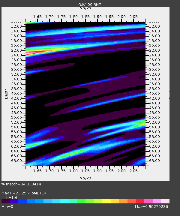
| Estimated Moho Depth: |
23.25 km |
| Estimated Crust Vp/Vs: |
1.60 |
| Assumed Crust Vp: |
6.472 km/s |
| Estimated Crust Vs: |
4.045 km/s |
| Estimated Crust Poisson's Ratio: |
0.18 |
|
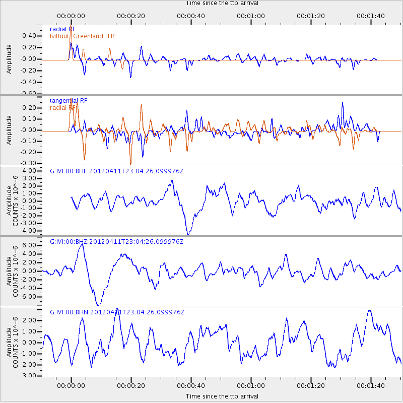
| Radial Match: |
84.830414 % |
| Radial Bump: |
400 |
| Transverse Match: |
74.05941 % |
| Transverse Bump: |
400 |
| SOD ConfigId: |
446234 |
| Insert Time: |
2012-07-04 10:57:51.354 +0000 |
| GWidth: |
2.5 |
| Max Bumps: |
400 |
| Tol: |
0.001 |
|
Signal To Noise
| Channel | StoN | STA | LTA |
| G:IVI:00:BHZ:20120411T23:04:26.099976Z | 3.9795218 | 3.7805198E-6 | 9.4999353E-7 |
| G:IVI:00:BHN:20120411T23:04:26.099976Z | 1.958185 | 1.3923565E-6 | 7.1104444E-7 |
| G:IVI:00:BHE:20120411T23:04:26.099976Z | 2.3281252 | 1.445336E-6 | 6.208154E-7 |
| Arrivals |
| Ps | 2.3 SECOND |
| PpPs | 8.8 SECOND |
| PsPs/PpSs | 11 SECOND |


