You are here: Home > Network List > G - GEOSCOPE Stations List
> Station INU Inuyama, Japan > Earthquake Result Viewer
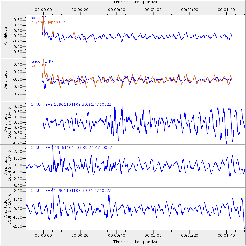
INU Inuyama, Japan - Earthquake Result Viewer
*The percent match for this event was below the threshold and hence no stack was calculated.
| Earthquake location: |
New Ireland Region, P.N.G. |
| Earthquake latitude/longitude: |
-1.3/149.5 |
| Earthquake time(UTC): |
1996/11/01 (306) 03:32:34 GMT |
| Earthquake Depth: |
33 km |
| Earthquake Magnitude: |
5.7 MB, 5.7 MS, 5.9 UNKNOWN, 5.8 MW |
| Earthquake Catalog/Contributor: |
WHDF/NEIC |
|
| Network: |
G GEOSCOPE |
| Station: |
INU Inuyama, Japan |
| Lat/Lon: |
35.35 N/137.03 E |
| Elevation: |
132 m |
|
| Distance: |
38.3 deg |
| Az: |
343.412 deg |
| Baz: |
159.565 deg |
| Ray Param: |
$rayparam |
*The percent match for this event was below the threshold and hence was not used in the summary stack. |
|
| Radial Match: |
48.079514 % |
| Radial Bump: |
400 |
| Transverse Match: |
48.665234 % |
| Transverse Bump: |
400 |
| SOD ConfigId: |
4480 |
| Insert Time: |
2010-02-26 23:28:18.698 +0000 |
| GWidth: |
2.5 |
| Max Bumps: |
400 |
| Tol: |
0.001 |
|
Signal To Noise
| Channel | StoN | STA | LTA |
| G:INU: :BHN:19961101T03:39:21.471002Z | 2.9041 | 7.35825E-7 | 2.5337457E-7 |
| G:INU: :BHE:19961101T03:39:21.471002Z | 1.7452734 | 7.2230324E-7 | 4.1386252E-7 |
| G:INU: :BHZ:19961101T03:39:21.471002Z | 0.6224228 | 1.4108036E-7 | 2.2666322E-7 |
| Arrivals |
| Ps | |
| PpPs | |
| PsPs/PpSs | |


