You are here: Home > Network List > G - GEOSCOPE Stations List
> Station INU Inuyama, Japan > Earthquake Result Viewer
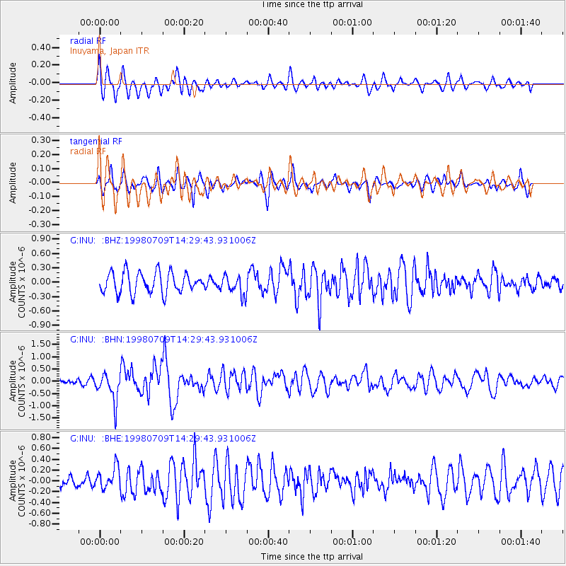
INU Inuyama, Japan - Earthquake Result Viewer
*The percent match for this event was below the threshold and hence no stack was calculated.
| Earthquake location: |
Armenia-Azerbaijan-Iran Bord Reg |
| Earthquake latitude/longitude: |
38.7/48.5 |
| Earthquake time(UTC): |
1998/07/09 (190) 14:19:18 GMT |
| Earthquake Depth: |
26 km |
| Earthquake Magnitude: |
5.9 MB, 6.0 UNKNOWN, 5.7 ME |
| Earthquake Catalog/Contributor: |
WHDF/NEIC |
|
| Network: |
G GEOSCOPE |
| Station: |
INU Inuyama, Japan |
| Lat/Lon: |
35.35 N/137.03 E |
| Elevation: |
132 m |
|
| Distance: |
68.0 deg |
| Az: |
61.839 deg |
| Baz: |
302.468 deg |
| Ray Param: |
$rayparam |
*The percent match for this event was below the threshold and hence was not used in the summary stack. |
|
| Radial Match: |
68.90353 % |
| Radial Bump: |
400 |
| Transverse Match: |
72.724846 % |
| Transverse Bump: |
400 |
| SOD ConfigId: |
4480 |
| Insert Time: |
2010-02-26 23:28:22.701 +0000 |
| GWidth: |
2.5 |
| Max Bumps: |
400 |
| Tol: |
0.001 |
|
Signal To Noise
| Channel | StoN | STA | LTA |
| G:INU: :BHN:19980709T14:29:43.931006Z | 1.9952028 | 5.997873E-7 | 3.006147E-7 |
| G:INU: :BHE:19980709T14:29:43.931006Z | 0.8768325 | 2.0688432E-7 | 2.359451E-7 |
| G:INU: :BHZ:19980709T14:29:43.931006Z | 0.9985737 | 2.135006E-7 | 2.1380554E-7 |
| Arrivals |
| Ps | |
| PpPs | |
| PsPs/PpSs | |


