You are here: Home > Network List > UW - Pacific Northwest Regional Seismic Network Stations List
> Station HEBO Mt. Hebo, OR CREST BB SMO > Earthquake Result Viewer
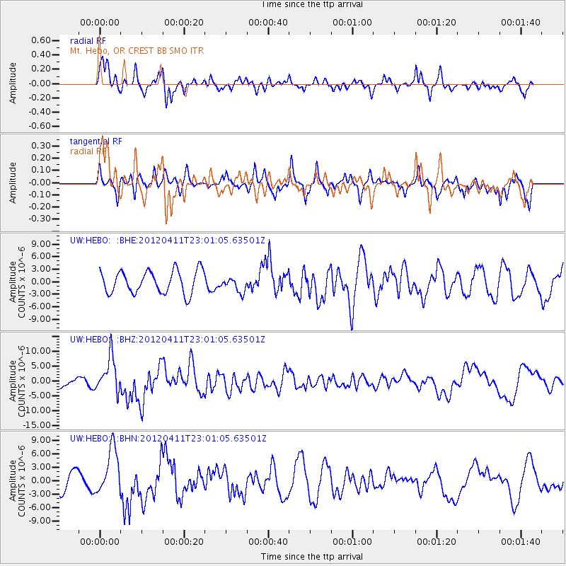
HEBO Mt. Hebo, OR CREST BB SMO - Earthquake Result Viewer
*The percent match for this event was below the threshold and hence no stack was calculated.
| Earthquake location: |
Michoacan, Mexico |
| Earthquake latitude/longitude: |
18.2/-102.7 |
| Earthquake time(UTC): |
2012/04/11 (102) 22:55:10 GMT |
| Earthquake Depth: |
20 km |
| Earthquake Magnitude: |
5.8 MB, 6.7 MS, 6.5 MW, 6.7 MW |
| Earthquake Catalog/Contributor: |
WHDF/NEIC |
|
| Network: |
UW Pacific Northwest Regional Seismic Network |
| Station: |
HEBO Mt. Hebo, OR CREST BB SMO |
| Lat/Lon: |
45.21 N/123.76 W |
| Elevation: |
875 m |
|
| Distance: |
32.1 deg |
| Az: |
331.462 deg |
| Baz: |
140.031 deg |
| Ray Param: |
$rayparam |
*The percent match for this event was below the threshold and hence was not used in the summary stack. |
|
| Radial Match: |
74.82647 % |
| Radial Bump: |
400 |
| Transverse Match: |
48.41372 % |
| Transverse Bump: |
370 |
| SOD ConfigId: |
446234 |
| Insert Time: |
2012-07-04 11:05:59.352 +0000 |
| GWidth: |
2.5 |
| Max Bumps: |
400 |
| Tol: |
0.001 |
|
Signal To Noise
| Channel | StoN | STA | LTA |
| UW:HEBO: :BHZ:20120411T23:01:05.63501Z | 3.2108333 | 6.127753E-6 | 1.9084619E-6 |
| UW:HEBO: :BHN:20120411T23:01:05.63501Z | 1.5223831 | 5.291746E-6 | 3.4759623E-6 |
| UW:HEBO: :BHE:20120411T23:01:05.63501Z | 0.66870546 | 1.8160781E-6 | 2.7158117E-6 |
| Arrivals |
| Ps | |
| PpPs | |
| PsPs/PpSs | |


