You are here: Home > Network List > UW - Pacific Northwest Regional Seismic Network Stations List
> Station MRBL Marblemount, WA, USA > Earthquake Result Viewer
MRBL Marblemount, WA, USA - Earthquake Result Viewer
| Earthquake location: |
Michoacan, Mexico |
| Earthquake latitude/longitude: |
18.2/-102.7 |
| Earthquake time(UTC): |
2012/04/11 (102) 22:55:10 GMT |
| Earthquake Depth: |
20 km |
| Earthquake Magnitude: |
5.8 MB, 6.7 MS, 6.5 MW, 6.7 MW |
| Earthquake Catalog/Contributor: |
WHDF/NEIC |
|
| Network: |
UW Pacific Northwest Regional Seismic Network |
| Station: |
MRBL Marblemount, WA, USA |
| Lat/Lon: |
48.52 N/121.48 W |
| Elevation: |
75 m |
|
| Distance: |
33.9 deg |
| Az: |
337.384 deg |
| Baz: |
146.653 deg |
| Ray Param: |
0.077995345 |
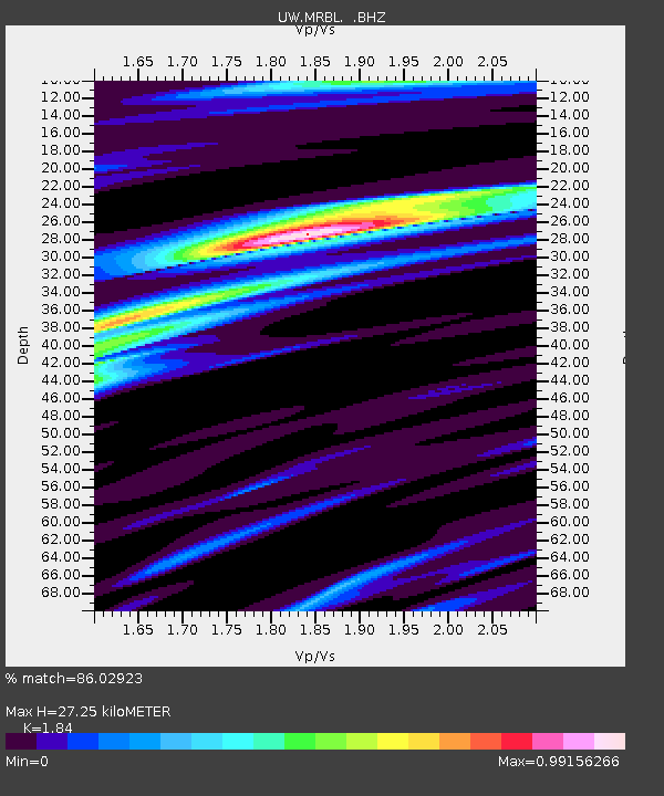
| Estimated Moho Depth: |
27.25 km |
| Estimated Crust Vp/Vs: |
1.84 |
| Assumed Crust Vp: |
6.566 km/s |
| Estimated Crust Vs: |
3.569 km/s |
| Estimated Crust Poisson's Ratio: |
0.29 |
|
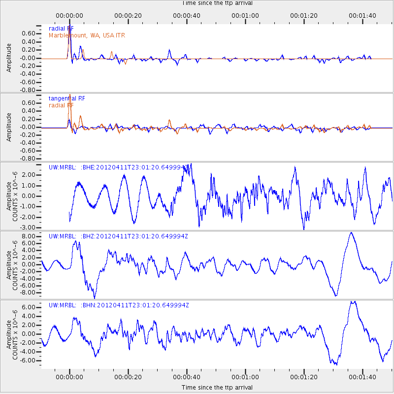
| Radial Match: |
86.02923 % |
| Radial Bump: |
376 |
| Transverse Match: |
48.84517 % |
| Transverse Bump: |
400 |
| SOD ConfigId: |
446234 |
| Insert Time: |
2012-07-04 11:06:09.240 +0000 |
| GWidth: |
2.5 |
| Max Bumps: |
400 |
| Tol: |
0.001 |
|
Signal To Noise
| Channel | StoN | STA | LTA |
| UW:MRBL: :BHZ:20120411T23:01:20.649994Z | 4.4671593 | 4.1644603E-6 | 9.3223895E-7 |
| UW:MRBL: :BHN:20120411T23:01:20.649994Z | 1.5089017 | 2.2340566E-6 | 1.4805846E-6 |
| UW:MRBL: :BHE:20120411T23:01:20.649994Z | 0.75983095 | 8.7475286E-7 | 1.1512467E-6 |
| Arrivals |
| Ps | 3.8 SECOND |
| PpPs | 11 SECOND |
| PsPs/PpSs | 15 SECOND |


