You are here: Home > Network List > G - GEOSCOPE Stations List
> Station INU Inuyama, Japan > Earthquake Result Viewer
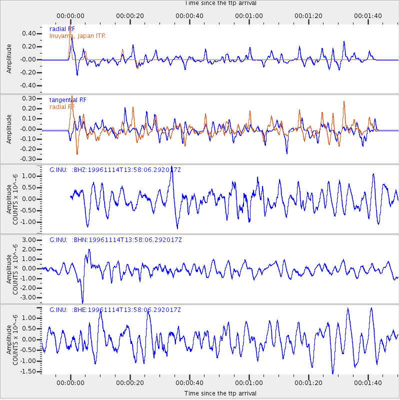
INU Inuyama, Japan - Earthquake Result Viewer
*The percent match for this event was below the threshold and hence no stack was calculated.
| Earthquake location: |
Fiji Islands Region |
| Earthquake latitude/longitude: |
-21.2/-176.6 |
| Earthquake time(UTC): |
1996/11/14 (319) 13:47:38 GMT |
| Earthquake Depth: |
192 km |
| Earthquake Magnitude: |
5.9 MB, 6.2 UNKNOWN, 6.1 MW |
| Earthquake Catalog/Contributor: |
WHDF/NEIC |
|
| Network: |
G GEOSCOPE |
| Station: |
INU Inuyama, Japan |
| Lat/Lon: |
35.35 N/137.03 E |
| Elevation: |
132 m |
|
| Distance: |
71.4 deg |
| Az: |
321.385 deg |
| Baz: |
134.584 deg |
| Ray Param: |
$rayparam |
*The percent match for this event was below the threshold and hence was not used in the summary stack. |
|
| Radial Match: |
66.42057 % |
| Radial Bump: |
400 |
| Transverse Match: |
64.51056 % |
| Transverse Bump: |
400 |
| SOD ConfigId: |
4480 |
| Insert Time: |
2010-02-26 23:28:30.818 +0000 |
| GWidth: |
2.5 |
| Max Bumps: |
400 |
| Tol: |
0.001 |
|
Signal To Noise
| Channel | StoN | STA | LTA |
| G:INU: :BHN:19961114T13:58:06.292017Z | 2.3028061 | 1.2845909E-6 | 5.5783715E-7 |
| G:INU: :BHE:19961114T13:58:06.292017Z | 0.68941915 | 2.9601586E-7 | 4.2936995E-7 |
| G:INU: :BHZ:19961114T13:58:06.292017Z | 1.4090576 | 5.806592E-7 | 4.120905E-7 |
| Arrivals |
| Ps | |
| PpPs | |
| PsPs/PpSs | |


