You are here: Home > Network List > G - GEOSCOPE Stations List
> Station INU Inuyama, Japan > Earthquake Result Viewer
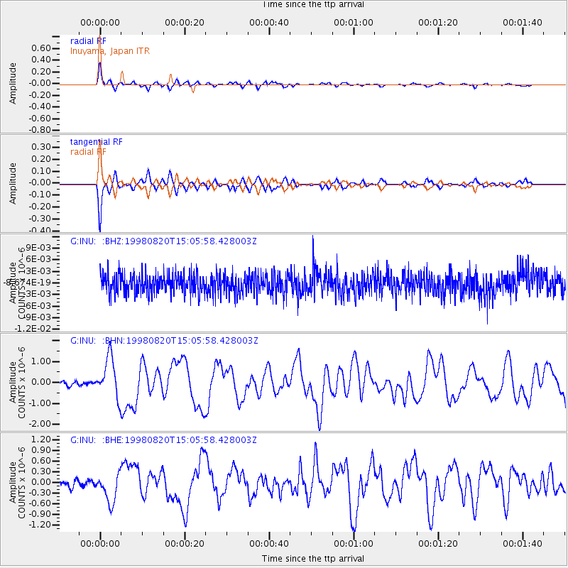
INU Inuyama, Japan - Earthquake Result Viewer
*The percent match for this event was below the threshold and hence no stack was calculated.
| Earthquake location: |
Rat Islands, Aleutian Islands |
| Earthquake latitude/longitude: |
51.6/175.2 |
| Earthquake time(UTC): |
1998/08/20 (232) 15:00:08 GMT |
| Earthquake Depth: |
33 km |
| Earthquake Magnitude: |
5.6 MB, 6.0 MS, 6.2 UNKNOWN, 6.2 MW |
| Earthquake Catalog/Contributor: |
WHDF/NEIC |
|
| Network: |
G GEOSCOPE |
| Station: |
INU Inuyama, Japan |
| Lat/Lon: |
35.35 N/137.03 E |
| Elevation: |
132 m |
|
| Distance: |
31.7 deg |
| Az: |
254.208 deg |
| Baz: |
47.214 deg |
| Ray Param: |
$rayparam |
*The percent match for this event was below the threshold and hence was not used in the summary stack. |
|
| Radial Match: |
73.79359 % |
| Radial Bump: |
400 |
| Transverse Match: |
73.62356 % |
| Transverse Bump: |
400 |
| SOD ConfigId: |
4480 |
| Insert Time: |
2010-02-26 23:28:33.213 +0000 |
| GWidth: |
2.5 |
| Max Bumps: |
400 |
| Tol: |
0.001 |
|
Signal To Noise
| Channel | StoN | STA | LTA |
| G:INU: :BHN:19980820T15:05:58.428003Z | 9.989984 | 9.882898E-7 | 9.892807E-8 |
| G:INU: :BHE:19980820T15:05:58.428003Z | 4.0216193 | 4.1601132E-7 | 1.03443725E-7 |
| G:INU: :BHZ:19980820T15:05:58.428003Z | 1.0053809 | 2.428111E-9 | 2.4151159E-9 |
| Arrivals |
| Ps | |
| PpPs | |
| PsPs/PpSs | |


