You are here: Home > Network List > AK - Alaska Regional Network Stations List
> Station WRH Wood River Hill > Earthquake Result Viewer
WRH Wood River Hill - Earthquake Result Viewer
| Earthquake location: |
Baja California, Mexico |
| Earthquake latitude/longitude: |
28.7/-113.1 |
| Earthquake time(UTC): |
2012/04/12 (103) 07:15:48 GMT |
| Earthquake Depth: |
13 km |
| Earthquake Magnitude: |
6.2 MB, 6.9 MS, 7.0 MW, 6.9 MW |
| Earthquake Catalog/Contributor: |
WHDF/NEIC |
|
| Network: |
AK Alaska Regional Network |
| Station: |
WRH Wood River Hill |
| Lat/Lon: |
64.47 N/148.09 W |
| Elevation: |
343 m |
|
| Distance: |
42.1 deg |
| Az: |
338.233 deg |
| Baz: |
131.248 deg |
| Ray Param: |
0.07338532 |
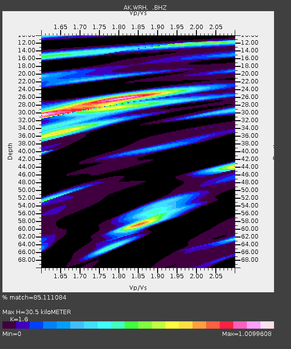
| Estimated Moho Depth: |
30.5 km |
| Estimated Crust Vp/Vs: |
1.60 |
| Assumed Crust Vp: |
6.566 km/s |
| Estimated Crust Vs: |
4.104 km/s |
| Estimated Crust Poisson's Ratio: |
0.18 |
|
| Radial Match: |
85.111084 % |
| Radial Bump: |
400 |
| Transverse Match: |
67.02397 % |
| Transverse Bump: |
400 |
| SOD ConfigId: |
446234 |
| Insert Time: |
2012-07-04 11:21:59.859 +0000 |
| GWidth: |
2.5 |
| Max Bumps: |
400 |
| Tol: |
0.001 |
|

Signal To Noise
| Channel | StoN | STA | LTA |
| AK:WRH: :BHZ:20120412T07:23:08.967987Z | 1.8313044 | 4.2051272E-7 | 2.2962469E-7 |
| AK:WRH: :BHN:20120412T07:23:08.967987Z | 0.5140108 | 1.4925813E-7 | 2.9037938E-7 |
| AK:WRH: :BHE:20120412T07:23:08.967987Z | 0.9474023 | 2.0781751E-7 | 2.1935507E-7 |
| Arrivals |
| Ps | 3.0 SECOND |
| PpPs | 11 SECOND |
| PsPs/PpSs | 14 SECOND |


