You are here: Home > Network List > CI - Caltech Regional Seismic Network Stations List
> Station SWS Sam W. Stewart, Westmorland, CA, USA > Earthquake Result Viewer
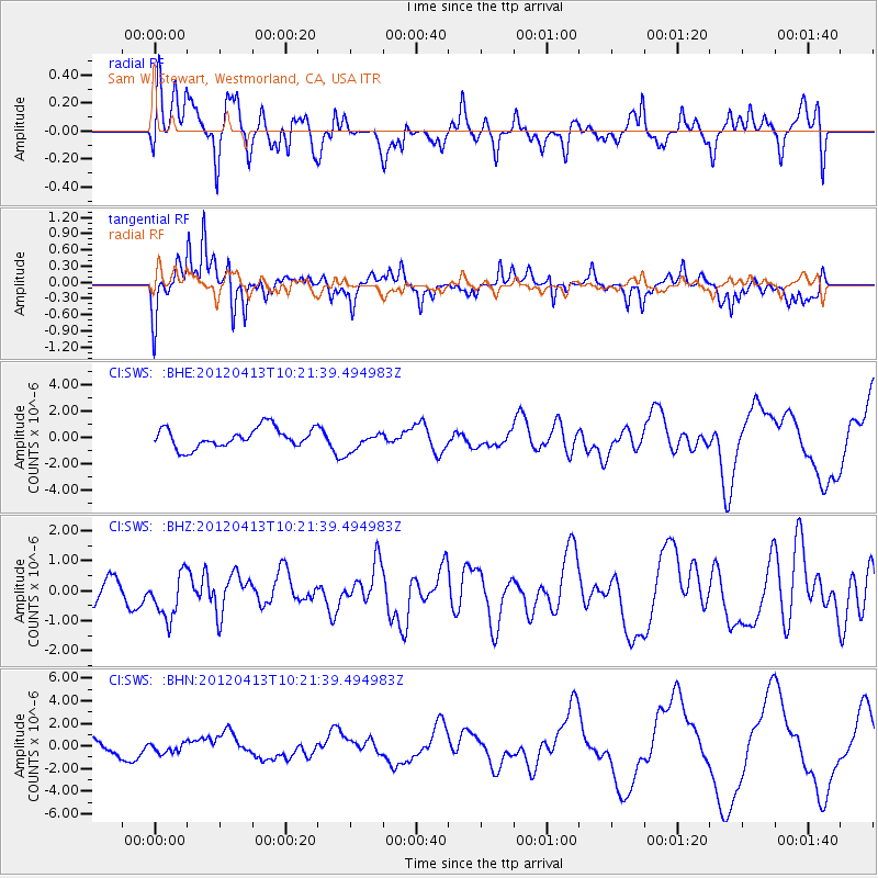
SWS Sam W. Stewart, Westmorland, CA, USA - Earthquake Result Viewer
*The percent match for this event was below the threshold and hence no stack was calculated.
| Earthquake location: |
Near East Coast Of Honshu, Japan |
| Earthquake latitude/longitude: |
37.0/141.2 |
| Earthquake time(UTC): |
2012/04/13 (104) 10:10:01 GMT |
| Earthquake Depth: |
11 km |
| Earthquake Magnitude: |
5.6 MB, 5.4 MS, 5.7 MW, 5.7 MW |
| Earthquake Catalog/Contributor: |
WHDF/NEIC |
|
| Network: |
CI Caltech Regional Seismic Network |
| Station: |
SWS Sam W. Stewart, Westmorland, CA, USA |
| Lat/Lon: |
32.94 N/115.80 W |
| Elevation: |
140 m |
|
| Distance: |
80.1 deg |
| Az: |
56.262 deg |
| Baz: |
307.643 deg |
| Ray Param: |
$rayparam |
*The percent match for this event was below the threshold and hence was not used in the summary stack. |
|
| Radial Match: |
62.369663 % |
| Radial Bump: |
400 |
| Transverse Match: |
68.66933 % |
| Transverse Bump: |
293 |
| SOD ConfigId: |
446234 |
| Insert Time: |
2012-07-04 11:40:03.118 +0000 |
| GWidth: |
2.5 |
| Max Bumps: |
400 |
| Tol: |
0.001 |
|
Signal To Noise
| Channel | StoN | STA | LTA |
| CI:SWS: :BHZ:20120413T10:21:39.494983Z | 1.9634768 | 7.644735E-7 | 3.8934687E-7 |
| CI:SWS: :BHN:20120413T10:21:39.494983Z | 0.81808174 | 4.430127E-7 | 5.415262E-7 |
| CI:SWS: :BHE:20120413T10:21:39.494983Z | 1.0060931 | 7.4650853E-7 | 7.4198744E-7 |
| Arrivals |
| Ps | |
| PpPs | |
| PsPs/PpSs | |


