You are here: Home > Network List > IW - Intermountain West Stations List
> Station MOOW Moose Ponds, Wyoming, USA > Earthquake Result Viewer
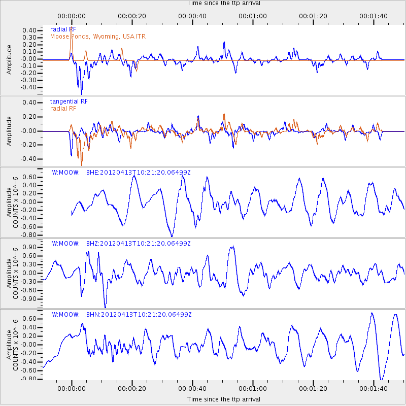
MOOW Moose Ponds, Wyoming, USA - Earthquake Result Viewer
*The percent match for this event was below the threshold and hence no stack was calculated.
| Earthquake location: |
Near East Coast Of Honshu, Japan |
| Earthquake latitude/longitude: |
37.0/141.2 |
| Earthquake time(UTC): |
2012/04/13 (104) 10:10:01 GMT |
| Earthquake Depth: |
11 km |
| Earthquake Magnitude: |
5.6 MB, 5.4 MS, 5.7 MW, 5.7 MW |
| Earthquake Catalog/Contributor: |
WHDF/NEIC |
|
| Network: |
IW Intermountain West |
| Station: |
MOOW Moose Ponds, Wyoming, USA |
| Lat/Lon: |
43.75 N/110.74 W |
| Elevation: |
2128 m |
|
| Distance: |
76.6 deg |
| Az: |
45.091 deg |
| Baz: |
308.51 deg |
| Ray Param: |
$rayparam |
*The percent match for this event was below the threshold and hence was not used in the summary stack. |
|
| Radial Match: |
56.944447 % |
| Radial Bump: |
317 |
| Transverse Match: |
61.786495 % |
| Transverse Bump: |
389 |
| SOD ConfigId: |
446234 |
| Insert Time: |
2012-07-04 11:44:34.912 +0000 |
| GWidth: |
2.5 |
| Max Bumps: |
400 |
| Tol: |
0.001 |
|
Signal To Noise
| Channel | StoN | STA | LTA |
| IW:MOOW: :BHZ:20120413T10:21:20.06499Z | 1.0856452 | 3.170735E-7 | 2.9205995E-7 |
| IW:MOOW: :BHN:20120413T10:21:20.06499Z | 1.1174593 | 3.333593E-7 | 2.9831898E-7 |
| IW:MOOW: :BHE:20120413T10:21:20.06499Z | 1.8116963 | 4.8387227E-7 | 2.6708247E-7 |
| Arrivals |
| Ps | |
| PpPs | |
| PsPs/PpSs | |


