You are here: Home > Network List > TA - USArray Transportable Network (new EarthScope stations) Stations List
> Station N23A Red Feather Lakes, CO, USA > Earthquake Result Viewer
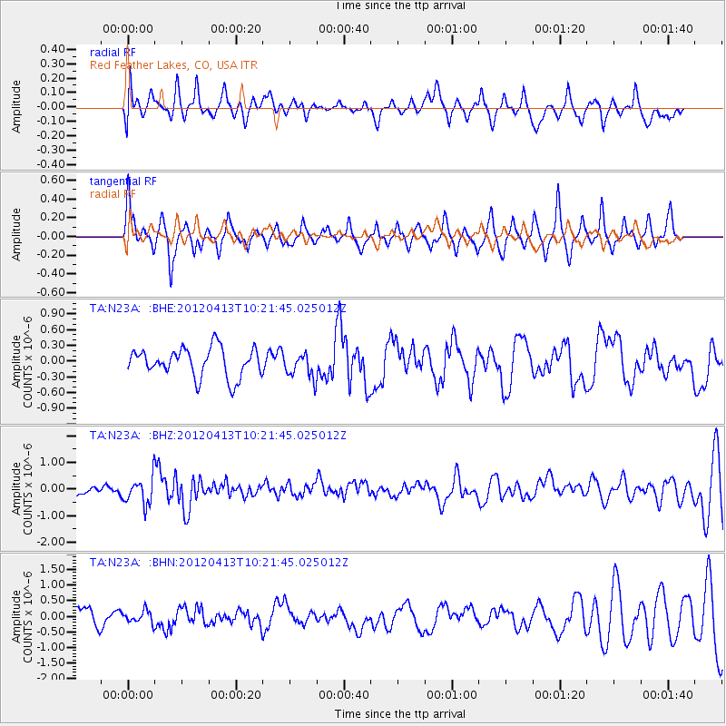
N23A Red Feather Lakes, CO, USA - Earthquake Result Viewer
*The percent match for this event was below the threshold and hence no stack was calculated.
| Earthquake location: |
Near East Coast Of Honshu, Japan |
| Earthquake latitude/longitude: |
37.0/141.2 |
| Earthquake time(UTC): |
2012/04/13 (104) 10:10:01 GMT |
| Earthquake Depth: |
11 km |
| Earthquake Magnitude: |
5.6 MB, 5.4 MS, 5.7 MW, 5.7 MW |
| Earthquake Catalog/Contributor: |
WHDF/NEIC |
|
| Network: |
TA USArray Transportable Network (new EarthScope stations) |
| Station: |
N23A Red Feather Lakes, CO, USA |
| Lat/Lon: |
40.89 N/105.94 W |
| Elevation: |
2458 m |
|
| Distance: |
81.1 deg |
| Az: |
44.975 deg |
| Baz: |
311.71 deg |
| Ray Param: |
$rayparam |
*The percent match for this event was below the threshold and hence was not used in the summary stack. |
|
| Radial Match: |
31.6126 % |
| Radial Bump: |
400 |
| Transverse Match: |
61.26833 % |
| Transverse Bump: |
322 |
| SOD ConfigId: |
446234 |
| Insert Time: |
2012-07-04 11:49:03.686 +0000 |
| GWidth: |
2.5 |
| Max Bumps: |
400 |
| Tol: |
0.001 |
|
Signal To Noise
| Channel | StoN | STA | LTA |
| TA:N23A: :BHZ:20120413T10:21:45.025012Z | 2.0352776 | 5.0877844E-7 | 2.4997988E-7 |
| TA:N23A: :BHN:20120413T10:21:45.025012Z | 0.6696266 | 2.0115225E-7 | 3.0039465E-7 |
| TA:N23A: :BHE:20120413T10:21:45.025012Z | 0.87913585 | 2.4209524E-7 | 2.7537862E-7 |
| Arrivals |
| Ps | |
| PpPs | |
| PsPs/PpSs | |


