You are here: Home > Network List > G - GEOSCOPE Stations List
> Station KIP Kipapa, Hawai, U.S.A. (Pacific Ocean) > Earthquake Result Viewer
KIP Kipapa, Hawai, U.S.A. (Pacific Ocean) - Earthquake Result Viewer
| Earthquake location: |
Vanuatu Islands Region |
| Earthquake latitude/longitude: |
-19.5/173.8 |
| Earthquake time(UTC): |
2000/02/25 (056) 01:43:58 GMT |
| Earthquake Depth: |
33 km |
| Earthquake Magnitude: |
6.1 MB, 7.1 MS, 7.1 MW, 7.0 MW |
| Earthquake Catalog/Contributor: |
WHDF/NEIC |
|
| Network: |
G GEOSCOPE |
| Station: |
KIP Kipapa, Hawai, U.S.A. (Pacific Ocean) |
| Lat/Lon: |
21.42 N/158.01 W |
| Elevation: |
70 m |
|
| Distance: |
49.2 deg |
| Az: |
35.552 deg |
| Baz: |
216.056 deg |
| Ray Param: |
0.068820305 |
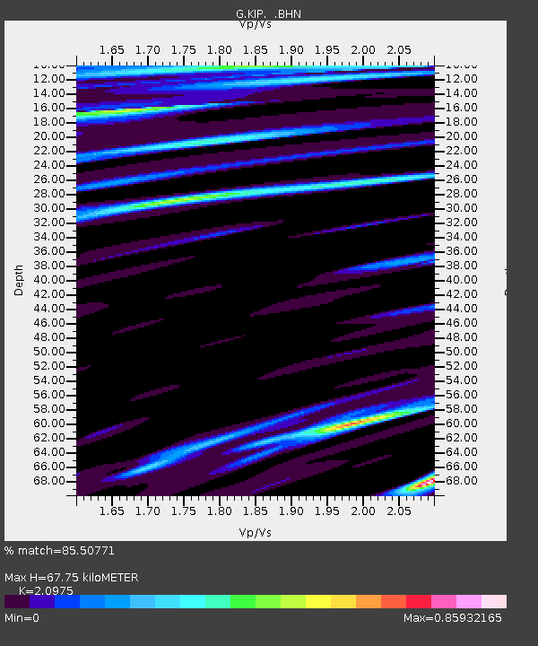
| Estimated Moho Depth: |
67.75 km |
| Estimated Crust Vp/Vs: |
2.10 |
| Assumed Crust Vp: |
4.24 km/s |
| Estimated Crust Vs: |
2.021 km/s |
| Estimated Crust Poisson's Ratio: |
0.35 |
|
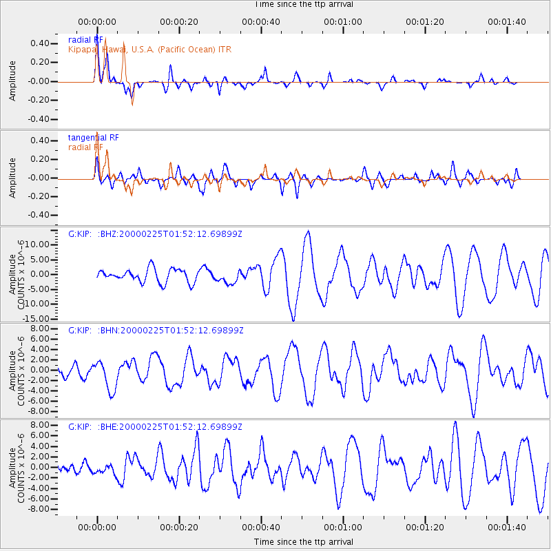
| Radial Match: |
85.50771 % |
| Radial Bump: |
400 |
| Transverse Match: |
57.78381 % |
| Transverse Bump: |
400 |
| SOD ConfigId: |
3744 |
| Insert Time: |
2010-02-26 23:28:51.895 +0000 |
| GWidth: |
2.5 |
| Max Bumps: |
400 |
| Tol: |
0.001 |
|
Signal To Noise
| Channel | StoN | STA | LTA |
| G:KIP: :BHN:20000225T01:52:12.69899Z | 1.8206686 | 2.9456621E-6 | 1.6179014E-6 |
| G:KIP: :BHE:20000225T01:52:12.69899Z | 0.6352623 | 8.7865214E-7 | 1.3831328E-6 |
| G:KIP: :BHZ:20000225T01:52:12.69899Z | 1.0087925 | 2.2336108E-6 | 2.2141428E-6 |
| Arrivals |
| Ps | 18 SECOND |
| PpPs | 48 SECOND |
| PsPs/PpSs | 66 SECOND |


