You are here: Home > Network List > TA - USArray Transportable Network (new EarthScope stations) Stations List
> Station H42A Shiocton, WI, USA > Earthquake Result Viewer
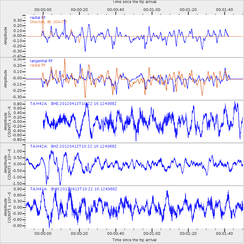
H42A Shiocton, WI, USA - Earthquake Result Viewer
*The percent match for this event was below the threshold and hence no stack was calculated.
| Earthquake location: |
Near East Coast Of Honshu, Japan |
| Earthquake latitude/longitude: |
37.0/141.2 |
| Earthquake time(UTC): |
2012/04/13 (104) 10:10:01 GMT |
| Earthquake Depth: |
11 km |
| Earthquake Magnitude: |
5.6 MB, 5.4 MS, 5.7 MW, 5.7 MW |
| Earthquake Catalog/Contributor: |
WHDF/NEIC |
|
| Network: |
TA USArray Transportable Network (new EarthScope stations) |
| Station: |
H42A Shiocton, WI, USA |
| Lat/Lon: |
44.51 N/88.53 W |
| Elevation: |
244 m |
|
| Distance: |
87.3 deg |
| Az: |
33.105 deg |
| Baz: |
322.323 deg |
| Ray Param: |
$rayparam |
*The percent match for this event was below the threshold and hence was not used in the summary stack. |
|
| Radial Match: |
69.61582 % |
| Radial Bump: |
400 |
| Transverse Match: |
49.43174 % |
| Transverse Bump: |
400 |
| SOD ConfigId: |
446234 |
| Insert Time: |
2012-07-04 12:03:27.995 +0000 |
| GWidth: |
2.5 |
| Max Bumps: |
400 |
| Tol: |
0.001 |
|
Signal To Noise
| Channel | StoN | STA | LTA |
| TA:H42A: :BHZ:20120413T10:22:16.124988Z | 2.6527586 | 7.4664246E-7 | 2.8145888E-7 |
| TA:H42A: :BHN:20120413T10:22:16.124988Z | 2.4086194 | 5.3833975E-7 | 2.2350552E-7 |
| TA:H42A: :BHE:20120413T10:22:16.124988Z | 0.6493379 | 1.9164594E-7 | 2.9514052E-7 |
| Arrivals |
| Ps | |
| PpPs | |
| PsPs/PpSs | |


