You are here: Home > Network List > TA - USArray Transportable Network (new EarthScope stations) Stations List
> Station MSTX Muleshoe, TX, USA > Earthquake Result Viewer
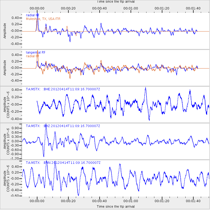
MSTX Muleshoe, TX, USA - Earthquake Result Viewer
*The percent match for this event was below the threshold and hence no stack was calculated.
| Earthquake location: |
Drake Passage |
| Earthquake latitude/longitude: |
-57.7/-65.3 |
| Earthquake time(UTC): |
2012/04/14 (105) 10:56:19 GMT |
| Earthquake Depth: |
15 km |
| Earthquake Magnitude: |
6.1 MB, 6.1 MS, 6.2 MW, 6.2 MW |
| Earthquake Catalog/Contributor: |
WHDF/NEIC |
|
| Network: |
TA USArray Transportable Network (new EarthScope stations) |
| Station: |
MSTX Muleshoe, TX, USA |
| Lat/Lon: |
33.97 N/102.77 W |
| Elevation: |
1167 m |
|
| Distance: |
96.6 deg |
| Az: |
329.411 deg |
| Baz: |
160.795 deg |
| Ray Param: |
$rayparam |
*The percent match for this event was below the threshold and hence was not used in the summary stack. |
|
| Radial Match: |
65.30349 % |
| Radial Bump: |
400 |
| Transverse Match: |
55.499733 % |
| Transverse Bump: |
400 |
| SOD ConfigId: |
446234 |
| Insert Time: |
2012-07-04 12:17:03.962 +0000 |
| GWidth: |
2.5 |
| Max Bumps: |
400 |
| Tol: |
0.001 |
|
Signal To Noise
| Channel | StoN | STA | LTA |
| TA:MSTX: :BHZ:20120414T11:09:16.700007Z | 3.6644511 | 3.841207E-7 | 1.0482353E-7 |
| TA:MSTX: :BHN:20120414T11:09:16.700007Z | 1.1138773 | 1.4288769E-7 | 1.2827955E-7 |
| TA:MSTX: :BHE:20120414T11:09:16.700007Z | 0.87935925 | 1.14541635E-7 | 1.302558E-7 |
| Arrivals |
| Ps | |
| PpPs | |
| PsPs/PpSs | |


