You are here: Home > Network List > TA - USArray Transportable Network (new EarthScope stations) Stations List
> Station Y46A Houston, MS, USA > Earthquake Result Viewer
Y46A Houston, MS, USA - Earthquake Result Viewer
| Earthquake location: |
Drake Passage |
| Earthquake latitude/longitude: |
-57.7/-65.3 |
| Earthquake time(UTC): |
2012/04/14 (105) 10:56:19 GMT |
| Earthquake Depth: |
15 km |
| Earthquake Magnitude: |
6.1 MB, 6.1 MS, 6.2 MW, 6.2 MW |
| Earthquake Catalog/Contributor: |
WHDF/NEIC |
|
| Network: |
TA USArray Transportable Network (new EarthScope stations) |
| Station: |
Y46A Houston, MS, USA |
| Lat/Lon: |
33.88 N/88.86 W |
| Elevation: |
109 m |
|
| Distance: |
93.3 deg |
| Az: |
340.552 deg |
| Baz: |
167.584 deg |
| Ray Param: |
0.041277055 |
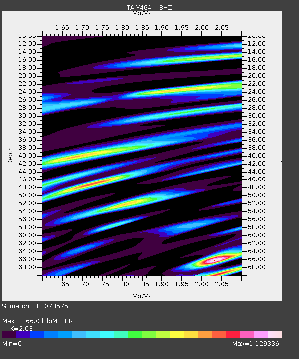
| Estimated Moho Depth: |
66.0 km |
| Estimated Crust Vp/Vs: |
2.03 |
| Assumed Crust Vp: |
6.201 km/s |
| Estimated Crust Vs: |
3.055 km/s |
| Estimated Crust Poisson's Ratio: |
0.34 |
|
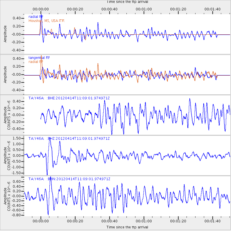
| Radial Match: |
81.078575 % |
| Radial Bump: |
400 |
| Transverse Match: |
72.10647 % |
| Transverse Bump: |
400 |
| SOD ConfigId: |
446234 |
| Insert Time: |
2012-07-04 12:22:43.202 +0000 |
| GWidth: |
2.5 |
| Max Bumps: |
400 |
| Tol: |
0.001 |
|
Signal To Noise
| Channel | StoN | STA | LTA |
| TA:Y46A: :BHZ:20120414T11:09:01.974971Z | 6.138041 | 5.775453E-7 | 9.409277E-8 |
| TA:Y46A: :BHN:20120414T11:09:01.974971Z | 2.3260496 | 2.6761904E-7 | 1.1505303E-7 |
| TA:Y46A: :BHE:20120414T11:09:01.974971Z | 1.15351 | 1.4987802E-7 | 1.2993215E-7 |
| Arrivals |
| Ps | 11 SECOND |
| PpPs | 32 SECOND |
| PsPs/PpSs | 43 SECOND |


