You are here: Home > Network List > G - GEOSCOPE Stations List
> Station KIP Kipapa, Hawai, U.S.A. (Pacific Ocean) > Earthquake Result Viewer
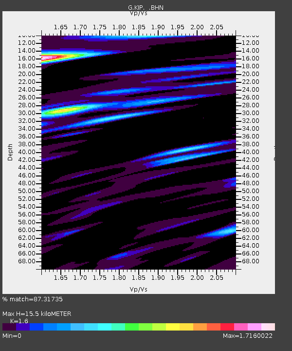
KIP Kipapa, Hawai, U.S.A. (Pacific Ocean) - Earthquake Result Viewer
| Earthquake location: |
Hokkaido, Japan Region |
| Earthquake latitude/longitude: |
43.4/143.3 |
| Earthquake time(UTC): |
1993/01/15 (015) 11:06:05 GMT |
| Earthquake Depth: |
100 km |
| Earthquake Magnitude: |
6.9 MB, 7.1 MS |
| Earthquake Catalog/Contributor: |
WHDF/NEIC |
|
| Network: |
G GEOSCOPE |
| Station: |
KIP Kipapa, Hawai, U.S.A. (Pacific Ocean) |
| Lat/Lon: |
21.42 N/158.01 W |
| Elevation: |
70 m |
|
| Distance: |
53.0 deg |
| Az: |
94.775 deg |
| Baz: |
308.783 deg |
| Ray Param: |
0.06604172 |
| Estimated Moho Depth: |
15.5 km |
| Estimated Crust Vp/Vs: |
1.60 |
| Assumed Crust Vp: |
4.24 km/s |
| Estimated Crust Vs: |
2.65 km/s |
| Estimated Crust Poisson's Ratio: |
0.18 |
|
| Radial Match: |
87.31735 % |
| Radial Bump: |
400 |
| Transverse Match: |
75.74872 % |
| Transverse Bump: |
400 |
| SOD ConfigId: |
16938 |
| Insert Time: |
2010-02-26 23:29:12.230 +0000 |
| GWidth: |
2.5 |
| Max Bumps: |
400 |
| Tol: |
0.001 |
|

Signal To Noise
| Channel | StoN | STA | LTA |
| G:KIP: :BHN:19930115T11:14:41.250Z | 2.9408863 | 4.508342E-6 | 1.5329874E-6 |
| G:KIP: :BHE:19930115T11:14:41.250Z | 2.440323 | 6.626253E-6 | 2.7153178E-6 |
| G:KIP: :BHZ:19930115T11:14:41.250Z | 4.7629695 | 1.1821866E-5 | 2.482037E-6 |
| Arrivals |
| Ps | 2.2 SECOND |
| PpPs | 9.3 SECOND |
| PsPs/PpSs | 12 SECOND |


