You are here: Home > Network List > TA - USArray Transportable Network (new EarthScope stations) Stations List
> Station 251A Midway, AL, USA > Earthquake Result Viewer
251A Midway, AL, USA - Earthquake Result Viewer
| Earthquake location: |
Drake Passage |
| Earthquake latitude/longitude: |
-57.7/-65.3 |
| Earthquake time(UTC): |
2012/04/14 (105) 10:56:19 GMT |
| Earthquake Depth: |
15 km |
| Earthquake Magnitude: |
6.1 MB, 6.1 MS, 6.2 MW, 6.2 MW |
| Earthquake Catalog/Contributor: |
WHDF/NEIC |
|
| Network: |
TA USArray Transportable Network (new EarthScope stations) |
| Station: |
251A Midway, AL, USA |
| Lat/Lon: |
32.09 N/85.41 W |
| Elevation: |
139 m |
|
| Distance: |
91.0 deg |
| Az: |
343.037 deg |
| Baz: |
169.359 deg |
| Ray Param: |
0.04163133 |
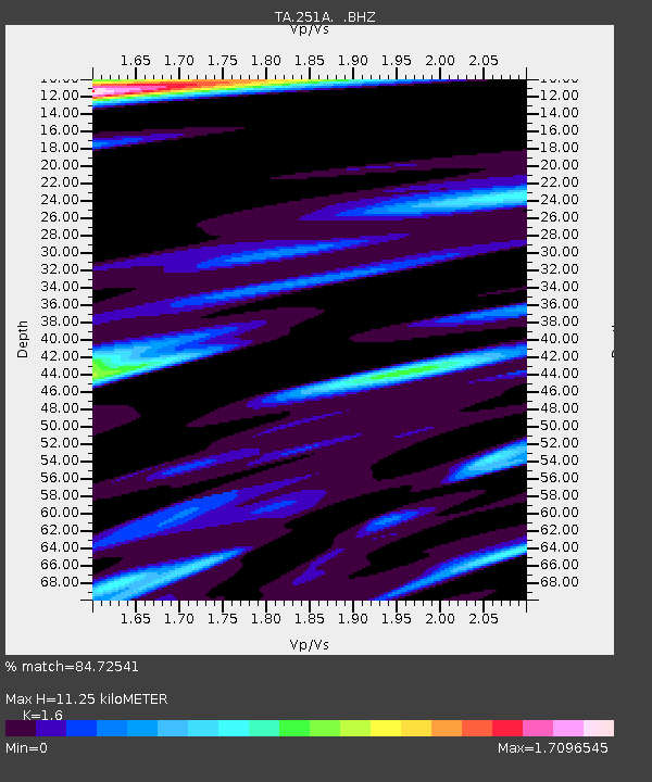
| Estimated Moho Depth: |
11.25 km |
| Estimated Crust Vp/Vs: |
1.60 |
| Assumed Crust Vp: |
6.719 km/s |
| Estimated Crust Vs: |
4.2 km/s |
| Estimated Crust Poisson's Ratio: |
0.18 |
|
| Radial Match: |
84.72541 % |
| Radial Bump: |
400 |
| Transverse Match: |
69.73988 % |
| Transverse Bump: |
400 |
| SOD ConfigId: |
446234 |
| Insert Time: |
2012-07-04 12:30:13.138 +0000 |
| GWidth: |
2.5 |
| Max Bumps: |
400 |
| Tol: |
0.001 |
|
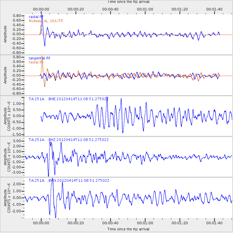
Signal To Noise
| Channel | StoN | STA | LTA |
| TA:251A: :BHZ:20120414T11:08:51.27502Z | 8.260743 | 1.1371244E-6 | 1.3765401E-7 |
| TA:251A: :BHN:20120414T11:08:51.27502Z | 2.1500738 | 5.061836E-7 | 2.3542616E-7 |
| TA:251A: :BHE:20120414T11:08:51.27502Z | 2.6455538 | 5.3641054E-7 | 2.0275925E-7 |
| Arrivals |
| Ps | 1.0 SECOND |
| PpPs | 4.2 SECOND |
| PsPs/PpSs | 5.3 SECOND |


