You are here: Home > Network List > G - GEOSCOPE Stations List
> Station KIP Kipapa - Hawaii, USA > Earthquake Result Viewer
KIP Kipapa - Hawaii, USA - Earthquake Result Viewer
| Earthquake location: |
Gulf Of California |
| Earthquake latitude/longitude: |
29.0/-112.9 |
| Earthquake time(UTC): |
2009/08/03 (215) 17:59:56 GMT |
| Earthquake Depth: |
10 km |
| Earthquake Magnitude: |
6.2 MB, 6.9 MW, 6.8 MW |
| Earthquake Catalog/Contributor: |
WHDF/NEIC |
|
| Network: |
G GEOSCOPE |
| Station: |
KIP Kipapa - Hawaii, USA |
| Lat/Lon: |
21.42 N/158.01 W |
| Elevation: |
70 m |
|
| Distance: |
41.3 deg |
| Az: |
270.039 deg |
| Baz: |
70.022 deg |
| Ray Param: |
0.07387296 |
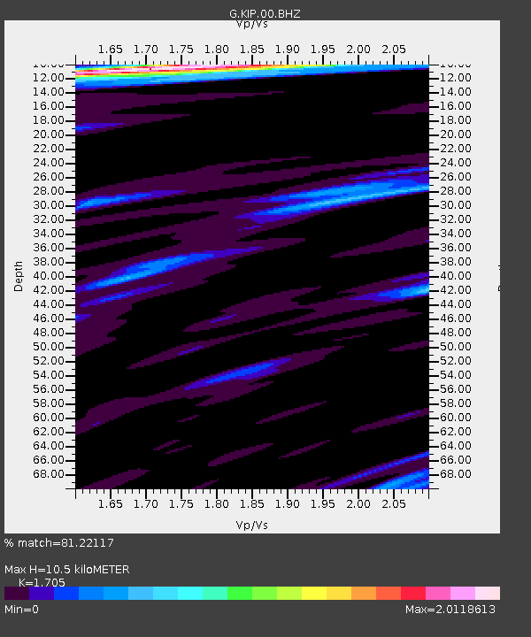
| Estimated Moho Depth: |
10.5 km |
| Estimated Crust Vp/Vs: |
1.71 |
| Assumed Crust Vp: |
4.24 km/s |
| Estimated Crust Vs: |
2.487 km/s |
| Estimated Crust Poisson's Ratio: |
0.24 |
|
| Radial Match: |
81.22117 % |
| Radial Bump: |
400 |
| Transverse Match: |
62.547157 % |
| Transverse Bump: |
400 |
| SOD ConfigId: |
2622 |
| Insert Time: |
2010-02-26 23:29:21.817 +0000 |
| GWidth: |
2.5 |
| Max Bumps: |
400 |
| Tol: |
0.001 |
|
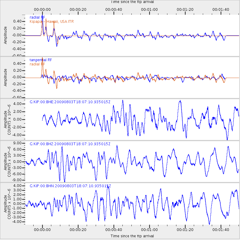
Signal To Noise
| Channel | StoN | STA | LTA |
| G:KIP:00:BHZ:20090803T18:07:10.935015Z | 3.01682 | 2.2858326E-6 | 7.57696E-7 |
| G:KIP:00:BHN:20090803T18:07:10.935015Z | 0.7135693 | 5.6079506E-7 | 7.8590136E-7 |
| G:KIP:00:BHE:20090803T18:07:10.935015Z | 1.5707023 | 1.3623444E-6 | 8.673473E-7 |
| Arrivals |
| Ps | 1.8 SECOND |
| PpPs | 6.5 SECOND |
| PsPs/PpSs | 8.3 SECOND |


