You are here: Home > Network List > G - GEOSCOPE Stations List
> Station KIP Kipapa, Hawaii, USA > Earthquake Result Viewer
KIP Kipapa, Hawaii, USA - Earthquake Result Viewer
| Earthquake location: |
Tonga Islands Region |
| Earthquake latitude/longitude: |
-23.0/-174.7 |
| Earthquake time(UTC): |
2009/03/19 (078) 18:17:40 GMT |
| Earthquake Depth: |
34 km |
| Earthquake Magnitude: |
7.0 MB, 7.6 MS, 7.6 MW, 7.6 MW |
| Earthquake Catalog/Contributor: |
WHDF/NEIC |
|
| Network: |
G GEOSCOPE |
| Station: |
KIP Kipapa, Hawaii, USA |
| Lat/Lon: |
21.42 N/158.01 W |
| Elevation: |
70 m |
|
| Distance: |
47.1 deg |
| Az: |
21.371 deg |
| Baz: |
201.117 deg |
| Ray Param: |
0.07015652 |
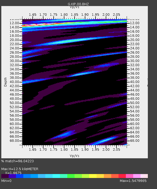
| Estimated Moho Depth: |
12.5 km |
| Estimated Crust Vp/Vs: |
1.67 |
| Assumed Crust Vp: |
4.24 km/s |
| Estimated Crust Vs: |
2.543 km/s |
| Estimated Crust Poisson's Ratio: |
0.22 |
|
| Radial Match: |
96.04223 % |
| Radial Bump: |
379 |
| Transverse Match: |
81.79166 % |
| Transverse Bump: |
400 |
| SOD ConfigId: |
2658 |
| Insert Time: |
2010-02-26 23:29:28.570 +0000 |
| GWidth: |
2.5 |
| Max Bumps: |
400 |
| Tol: |
0.001 |
|

Signal To Noise
| Channel | StoN | STA | LTA |
| G:KIP:00:BHZ:20090319T18:25:38.886013Z | 2.806154 | 8.745411E-6 | 3.1165114E-6 |
| G:KIP:00:BHN:20090319T18:25:38.886013Z | 5.20245 | 4.602612E-6 | 8.847009E-7 |
| G:KIP:00:BHE:20090319T18:25:38.886013Z | 2.4335322 | 4.0260684E-6 | 1.6544133E-6 |
| Arrivals |
| Ps | 2.0 SECOND |
| PpPs | 7.7 SECOND |
| PsPs/PpSs | 9.7 SECOND |


