You are here: Home > Network List > 1U - Mt. Paektu Seismic Network Stations List
> Station PDBD Paektu Bridge > Earthquake Result Viewer
PDBD Paektu Bridge - Earthquake Result Viewer
| Earthquake location: |
Solomon Islands |
| Earthquake latitude/longitude: |
-6.9/154.9 |
| Earthquake time(UTC): |
2014/05/07 (127) 04:20:33 GMT |
| Earthquake Depth: |
1.0 km |
| Earthquake Magnitude: |
6.1 MWP |
| Earthquake Catalog/Contributor: |
NEIC PDE/NEIC COMCAT |
|
| Network: |
1U Mt. Paektu Seismic Network |
| Station: |
PDBD Paektu Bridge |
| Lat/Lon: |
41.99 N/128.13 E |
| Elevation: |
2164 m |
|
| Distance: |
54.5 deg |
| Az: |
335.653 deg |
| Baz: |
146.704 deg |
| Ray Param: |
0.06543315 |
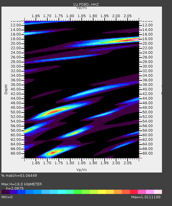
| Estimated Moho Depth: |
18.0 km |
| Estimated Crust Vp/Vs: |
2.10 |
| Assumed Crust Vp: |
6.472 km/s |
| Estimated Crust Vs: |
3.086 km/s |
| Estimated Crust Poisson's Ratio: |
0.35 |
|
| Radial Match: |
83.06449 % |
| Radial Bump: |
400 |
| Transverse Match: |
59.26158 % |
| Transverse Bump: |
400 |
| SOD ConfigId: |
3390531 |
| Insert Time: |
2019-04-11 18:27:01.938 +0000 |
| GWidth: |
2.5 |
| Max Bumps: |
400 |
| Tol: |
0.001 |
|

Signal To Noise
| Channel | StoN | STA | LTA |
| 1U:PDBD: :HHZ:20140507T04:29:32.650022Z | 2.9341536 | 2.302706E-7 | 7.8479395E-8 |
| 1U:PDBD: :HHN:20140507T04:29:32.650022Z | 1.1853074 | 1.6776528E-7 | 1.4153736E-7 |
| 1U:PDBD: :HHE:20140507T04:29:32.650022Z | 0.65952057 | 8.247472E-8 | 1.2505254E-7 |
| Arrivals |
| Ps | 3.2 SECOND |
| PpPs | 8.2 SECOND |
| PsPs/PpSs | 11 SECOND |


