You are here: Home > Network List > TA - USArray Transportable Network (new EarthScope stations) Stations List
> Station 242A Grayson, LA, USA > Earthquake Result Viewer
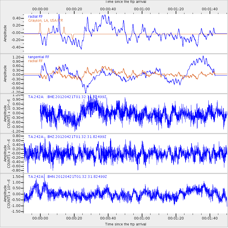
242A Grayson, LA, USA - Earthquake Result Viewer
*The percent match for this event was below the threshold and hence no stack was calculated.
| Earthquake location: |
Southern Mid-Atlantic Ridge |
| Earthquake latitude/longitude: |
-35.2/-16.2 |
| Earthquake time(UTC): |
2012/04/21 (112) 01:19:28 GMT |
| Earthquake Depth: |
10 km |
| Earthquake Magnitude: |
5.7 MW, 5.0 MB |
| Earthquake Catalog/Contributor: |
WHDF/NEIC |
|
| Network: |
TA USArray Transportable Network (new EarthScope stations) |
| Station: |
242A Grayson, LA, USA |
| Lat/Lon: |
32.06 N/92.15 W |
| Elevation: |
57 m |
|
| Distance: |
97.8 deg |
| Az: |
303.763 deg |
| Baz: |
126.719 deg |
| Ray Param: |
$rayparam |
*The percent match for this event was below the threshold and hence was not used in the summary stack. |
|
| Radial Match: |
43.736267 % |
| Radial Bump: |
400 |
| Transverse Match: |
42.63195 % |
| Transverse Bump: |
400 |
| SOD ConfigId: |
446234 |
| Insert Time: |
2012-07-13 14:29:20.362 +0000 |
| GWidth: |
2.5 |
| Max Bumps: |
400 |
| Tol: |
0.001 |
|
Signal To Noise
| Channel | StoN | STA | LTA |
| TA:242A: :BHZ:20120421T01:32:31.82499Z | 1.0172613 | 2.3546647E-7 | 2.3147099E-7 |
| TA:242A: :BHN:20120421T01:32:31.82499Z | 1.7301463 | 6.4086004E-7 | 3.70408E-7 |
| TA:242A: :BHE:20120421T01:32:31.82499Z | 1.9786104 | 7.591684E-7 | 3.8368768E-7 |
| Arrivals |
| Ps | |
| PpPs | |
| PsPs/PpSs | |


