You are here: Home > Network List > TA - USArray Transportable Network (new EarthScope stations) Stations List
> Station X46A Booneville, MS, USA > Earthquake Result Viewer
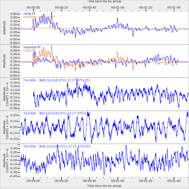
X46A Booneville, MS, USA - Earthquake Result Viewer
*The percent match for this event was below the threshold and hence no stack was calculated.
| Earthquake location: |
Southern Mid-Atlantic Ridge |
| Earthquake latitude/longitude: |
-35.2/-16.2 |
| Earthquake time(UTC): |
2012/04/21 (112) 01:19:28 GMT |
| Earthquake Depth: |
10 km |
| Earthquake Magnitude: |
5.7 MW, 5.0 MB |
| Earthquake Catalog/Contributor: |
WHDF/NEIC |
|
| Network: |
TA USArray Transportable Network (new EarthScope stations) |
| Station: |
X46A Booneville, MS, USA |
| Lat/Lon: |
34.56 N/88.58 W |
| Elevation: |
150 m |
|
| Distance: |
96.9 deg |
| Az: |
307.585 deg |
| Baz: |
128.183 deg |
| Ray Param: |
$rayparam |
*The percent match for this event was below the threshold and hence was not used in the summary stack. |
|
| Radial Match: |
42.747047 % |
| Radial Bump: |
400 |
| Transverse Match: |
50.94653 % |
| Transverse Bump: |
400 |
| SOD ConfigId: |
446234 |
| Insert Time: |
2012-07-13 14:29:57.926 +0000 |
| GWidth: |
2.5 |
| Max Bumps: |
400 |
| Tol: |
0.001 |
|
Signal To Noise
| Channel | StoN | STA | LTA |
| TA:X46A: :BHZ:20120421T01:32:27.975015Z | 0.78248346 | 5.8760484E-8 | 7.509485E-8 |
| TA:X46A: :BHN:20120421T01:32:27.975015Z | 2.726437 | 2.6946026E-7 | 9.883238E-8 |
| TA:X46A: :BHE:20120421T01:32:27.975015Z | 1.7374256 | 2.0114905E-7 | 1.157742E-7 |
| Arrivals |
| Ps | |
| PpPs | |
| PsPs/PpSs | |


