You are here: Home > Network List > G - GEOSCOPE Stations List
> Station INU Inuyama, Japan > Earthquake Result Viewer
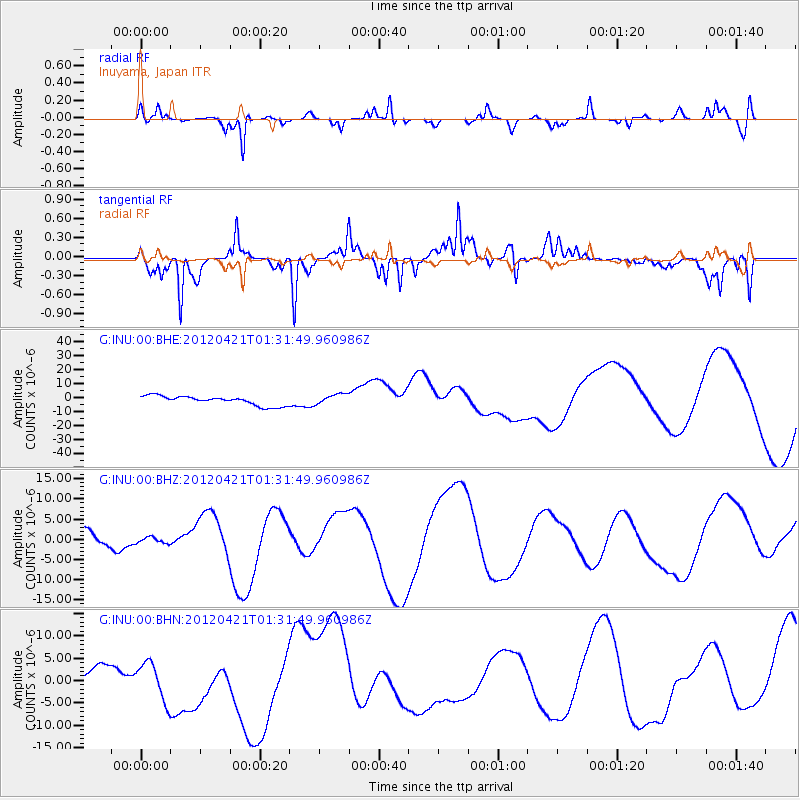
INU Inuyama, Japan - Earthquake Result Viewer
*The percent match for this event was below the threshold and hence no stack was calculated.
| Earthquake location: |
Irian Jaya Region, Indonesia |
| Earthquake latitude/longitude: |
-1.6/134.2 |
| Earthquake time(UTC): |
2012/04/21 (112) 01:25:13 GMT |
| Earthquake Depth: |
17 km |
| Earthquake Magnitude: |
5.6 MB, 6.0 MW |
| Earthquake Catalog/Contributor: |
WHDF/NEIC |
|
| Network: |
G GEOSCOPE |
| Station: |
INU Inuyama, Japan |
| Lat/Lon: |
35.35 N/137.03 E |
| Elevation: |
132 m |
|
| Distance: |
36.9 deg |
| Az: |
3.858 deg |
| Baz: |
184.72 deg |
| Ray Param: |
$rayparam |
*The percent match for this event was below the threshold and hence was not used in the summary stack. |
|
| Radial Match: |
56.745796 % |
| Radial Bump: |
374 |
| Transverse Match: |
80.36796 % |
| Transverse Bump: |
336 |
| SOD ConfigId: |
446234 |
| Insert Time: |
2012-07-13 14:37:34.448 +0000 |
| GWidth: |
2.5 |
| Max Bumps: |
400 |
| Tol: |
0.001 |
|
Signal To Noise
| Channel | StoN | STA | LTA |
| G:INU:00:BHZ:20120421T01:31:49.960986Z | 0.38320938 | 7.426306E-7 | 1.9379238E-6 |
| G:INU:00:BHN:20120421T01:31:49.960986Z | 2.176941 | 4.149624E-6 | 1.9061723E-6 |
| G:INU:00:BHE:20120421T01:31:49.960986Z | 1.1706403 | 3.82726E-6 | 3.2693733E-6 |
| Arrivals |
| Ps | |
| PpPs | |
| PsPs/PpSs | |


