You are here: Home > Network List > G - GEOSCOPE Stations List
> Station KIP Kipapa, Hawaii, USA > Earthquake Result Viewer
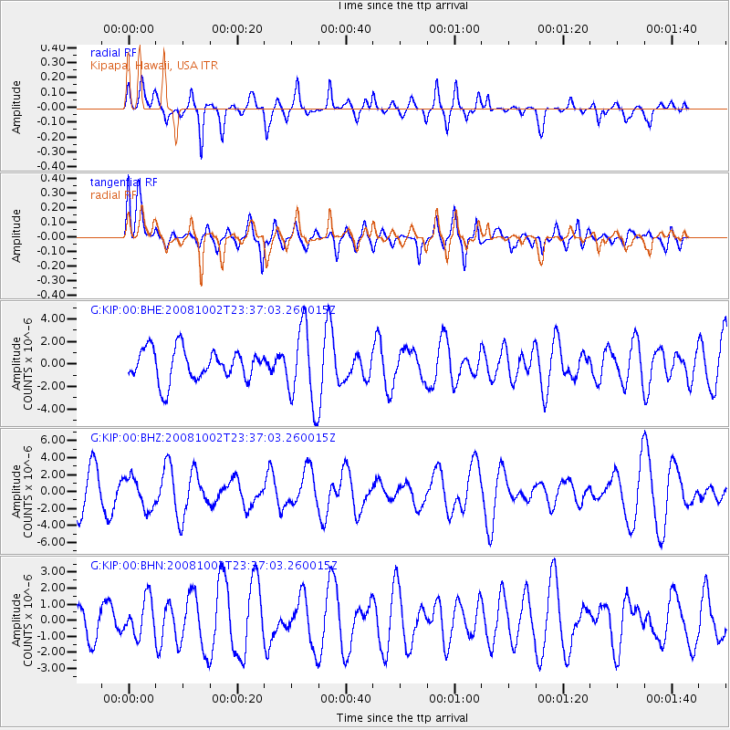
KIP Kipapa, Hawaii, USA - Earthquake Result Viewer
*The percent match for this event was below the threshold and hence no stack was calculated.
| Earthquake location: |
Southeast Of Loyalty Islands |
| Earthquake latitude/longitude: |
-23.0/169.9 |
| Earthquake time(UTC): |
2008/10/02 (276) 23:28:09 GMT |
| Earthquake Depth: |
10 km |
| Earthquake Magnitude: |
5.8 MB, 5.5 MS, 5.8 MW, 5.8 MW |
| Earthquake Catalog/Contributor: |
WHDF/NEIC |
|
| Network: |
G GEOSCOPE |
| Station: |
KIP Kipapa, Hawaii, USA |
| Lat/Lon: |
21.42 N/158.01 W |
| Elevation: |
70 m |
|
| Distance: |
54.1 deg |
| Az: |
37.686 deg |
| Baz: |
217.192 deg |
| Ray Param: |
$rayparam |
*The percent match for this event was below the threshold and hence was not used in the summary stack. |
|
| Radial Match: |
47.72173 % |
| Radial Bump: |
400 |
| Transverse Match: |
43.97711 % |
| Transverse Bump: |
400 |
| SOD ConfigId: |
2556 |
| Insert Time: |
2010-02-26 23:30:04.201 +0000 |
| GWidth: |
2.5 |
| Max Bumps: |
400 |
| Tol: |
0.001 |
|
Signal To Noise
| Channel | StoN | STA | LTA |
| G:KIP:00:BHZ:20081002T23:37:03.260015Z | 0.9815333 | 1.8511457E-6 | 1.8859735E-6 |
| G:KIP:00:BHN:20081002T23:37:03.260015Z | 1.0638248 | 1.1680468E-6 | 1.0979691E-6 |
| G:KIP:00:BHE:20081002T23:37:03.260015Z | 2.501452 | 3.463442E-6 | 1.3845727E-6 |
| Arrivals |
| Ps | |
| PpPs | |
| PsPs/PpSs | |


