You are here: Home > Network List > CI - Caltech Regional Seismic Network Stations List
> Station MPP McPhearson Peak > Earthquake Result Viewer
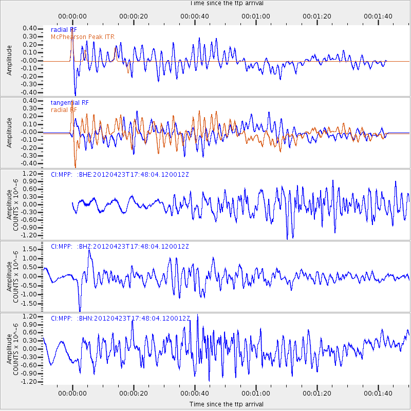
MPP McPhearson Peak - Earthquake Result Viewer
*The percent match for this event was below the threshold and hence no stack was calculated.
| Earthquake location: |
Kermadec Islands Region |
| Earthquake latitude/longitude: |
-28.6/-177.4 |
| Earthquake time(UTC): |
2012/04/23 (114) 17:36:21 GMT |
| Earthquake Depth: |
114 km |
| Earthquake Magnitude: |
5.8 MB, 6.0 MW, 6.0 MW |
| Earthquake Catalog/Contributor: |
WHDF/NEIC |
|
| Network: |
CI Caltech Regional Seismic Network |
| Station: |
MPP McPhearson Peak |
| Lat/Lon: |
34.89 N/119.81 W |
| Elevation: |
1739 m |
|
| Distance: |
83.3 deg |
| Az: |
44.335 deg |
| Baz: |
228.404 deg |
| Ray Param: |
$rayparam |
*The percent match for this event was below the threshold and hence was not used in the summary stack. |
|
| Radial Match: |
56.91879 % |
| Radial Bump: |
400 |
| Transverse Match: |
62.78896 % |
| Transverse Bump: |
400 |
| SOD ConfigId: |
446234 |
| Insert Time: |
2012-07-21 12:24:04.454 +0000 |
| GWidth: |
2.5 |
| Max Bumps: |
400 |
| Tol: |
0.001 |
|
Signal To Noise
| Channel | StoN | STA | LTA |
| CI:MPP: :BHZ:20120423T17:48:04.120012Z | 2.2878792 | 6.487039E-7 | 2.835394E-7 |
| CI:MPP: :BHN:20120423T17:48:04.120012Z | 1.3459281 | 4.961005E-7 | 3.6859362E-7 |
| CI:MPP: :BHE:20120423T17:48:04.120012Z | 1.3316923 | 2.232292E-7 | 1.676282E-7 |
| Arrivals |
| Ps | |
| PpPs | |
| PsPs/PpSs | |


