You are here: Home > Network List > ZJ12 - Transantarctic Mountains Northern Network Stations List
> Station GRAW East Antarctica > Earthquake Result Viewer
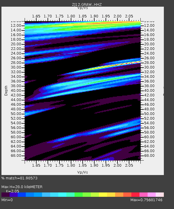
GRAW East Antarctica - Earthquake Result Viewer
| Earthquake location: |
Solomon Islands |
| Earthquake latitude/longitude: |
-6.9/154.9 |
| Earthquake time(UTC): |
2014/05/07 (127) 04:20:33 GMT |
| Earthquake Depth: |
1.0 km |
| Earthquake Magnitude: |
6.1 MWP |
| Earthquake Catalog/Contributor: |
NEIC PDE/NEIC COMCAT |
|
| Network: |
ZJ Transantarctic Mountains Northern Network |
| Station: |
GRAW East Antarctica |
| Lat/Lon: |
74.00 S/154.99 E |
| Elevation: |
2205 m |
|
| Distance: |
67.0 deg |
| Az: |
179.967 deg |
| Baz: |
359.883 deg |
| Ray Param: |
0.057262782 |
| Estimated Moho Depth: |
28.0 km |
| Estimated Crust Vp/Vs: |
2.05 |
| Assumed Crust Vp: |
6.168 km/s |
| Estimated Crust Vs: |
3.009 km/s |
| Estimated Crust Poisson's Ratio: |
0.34 |
|
| Radial Match: |
81.98573 % |
| Radial Bump: |
333 |
| Transverse Match: |
64.42122 % |
| Transverse Bump: |
372 |
| SOD ConfigId: |
3390531 |
| Insert Time: |
2019-04-11 18:31:17.289 +0000 |
| GWidth: |
2.5 |
| Max Bumps: |
400 |
| Tol: |
0.001 |
|

Signal To Noise
| Channel | StoN | STA | LTA |
| ZJ:GRAW: :HHZ:20140507T04:30:56.489988Z | 5.2070913 | 1.3619339E-6 | 2.6155368E-7 |
| ZJ:GRAW: :HHN:20140507T04:30:56.489988Z | 2.1035893 | 5.647999E-7 | 2.6849344E-7 |
| ZJ:GRAW: :HHE:20140507T04:30:56.489988Z | 0.6728516 | 2.1573337E-7 | 3.2062545E-7 |
| Arrivals |
| Ps | 4.9 SECOND |
| PpPs | 13 SECOND |
| PsPs/PpSs | 18 SECOND |


