You are here: Home > Network List > TA - USArray Transportable Network (new EarthScope stations) Stations List
> Station Y12C Blythe, CA, USA > Earthquake Result Viewer
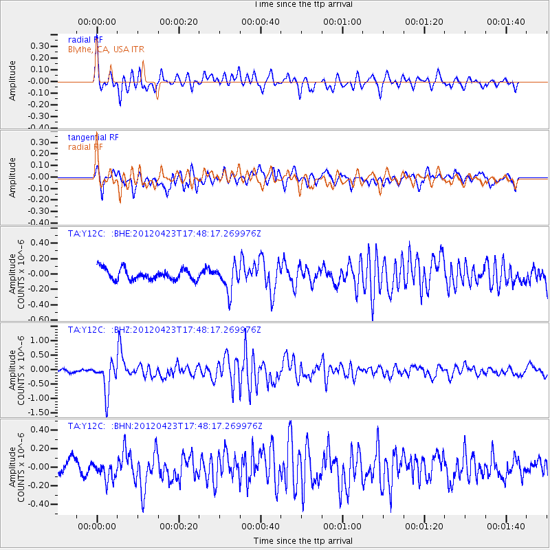
Y12C Blythe, CA, USA - Earthquake Result Viewer
*The percent match for this event was below the threshold and hence no stack was calculated.
| Earthquake location: |
Kermadec Islands Region |
| Earthquake latitude/longitude: |
-28.6/-177.4 |
| Earthquake time(UTC): |
2012/04/23 (114) 17:36:21 GMT |
| Earthquake Depth: |
114 km |
| Earthquake Magnitude: |
5.8 MB, 6.0 MW, 6.0 MW |
| Earthquake Catalog/Contributor: |
WHDF/NEIC |
|
| Network: |
TA USArray Transportable Network (new EarthScope stations) |
| Station: |
Y12C Blythe, CA, USA |
| Lat/Lon: |
33.75 N/114.52 W |
| Elevation: |
196 m |
|
| Distance: |
85.9 deg |
| Az: |
48.031 deg |
| Baz: |
231.722 deg |
| Ray Param: |
$rayparam |
*The percent match for this event was below the threshold and hence was not used in the summary stack. |
|
| Radial Match: |
77.52461 % |
| Radial Bump: |
400 |
| Transverse Match: |
70.39237 % |
| Transverse Bump: |
400 |
| SOD ConfigId: |
446234 |
| Insert Time: |
2012-07-21 12:30:42.566 +0000 |
| GWidth: |
2.5 |
| Max Bumps: |
400 |
| Tol: |
0.001 |
|
Signal To Noise
| Channel | StoN | STA | LTA |
| TA:Y12C: :BHZ:20120423T17:48:17.269976Z | 4.792084 | 5.577983E-7 | 1.16399924E-7 |
| TA:Y12C: :BHN:20120423T17:48:17.269976Z | 1.1017458 | 1.0029217E-7 | 9.1030216E-8 |
| TA:Y12C: :BHE:20120423T17:48:17.269976Z | 2.4524226 | 1.7468525E-7 | 7.122968E-8 |
| Arrivals |
| Ps | |
| PpPs | |
| PsPs/PpSs | |


