You are here: Home > Network List > UW - Pacific Northwest Regional Seismic Network Stations List
> Station LEBA Lebam, WA, USA > Earthquake Result Viewer
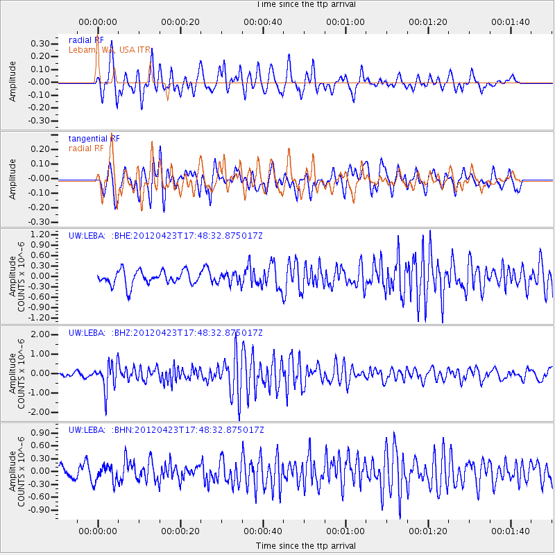
LEBA Lebam, WA, USA - Earthquake Result Viewer
*The percent match for this event was below the threshold and hence no stack was calculated.
| Earthquake location: |
Kermadec Islands Region |
| Earthquake latitude/longitude: |
-28.6/-177.4 |
| Earthquake time(UTC): |
2012/04/23 (114) 17:36:21 GMT |
| Earthquake Depth: |
114 km |
| Earthquake Magnitude: |
5.8 MB, 6.0 MW, 6.0 MW |
| Earthquake Catalog/Contributor: |
WHDF/NEIC |
|
| Network: |
UW Pacific Northwest Regional Seismic Network |
| Station: |
LEBA Lebam, WA, USA |
| Lat/Lon: |
46.55 N/123.56 W |
| Elevation: |
73 m |
|
| Distance: |
89.2 deg |
| Az: |
33.874 deg |
| Baz: |
225.267 deg |
| Ray Param: |
$rayparam |
*The percent match for this event was below the threshold and hence was not used in the summary stack. |
|
| Radial Match: |
67.60318 % |
| Radial Bump: |
400 |
| Transverse Match: |
71.97299 % |
| Transverse Bump: |
400 |
| SOD ConfigId: |
446234 |
| Insert Time: |
2012-07-21 12:35:47.600 +0000 |
| GWidth: |
2.5 |
| Max Bumps: |
400 |
| Tol: |
0.001 |
|
Signal To Noise
| Channel | StoN | STA | LTA |
| UW:LEBA: :BHZ:20120423T17:48:32.875017Z | 7.1526275 | 6.8812795E-7 | 9.620632E-8 |
| UW:LEBA: :BHN:20120423T17:48:32.875017Z | 1.51367 | 1.9943957E-7 | 1.3175894E-7 |
| UW:LEBA: :BHE:20120423T17:48:32.875017Z | 0.7336348 | 1.4802232E-7 | 2.0176567E-7 |
| Arrivals |
| Ps | |
| PpPs | |
| PsPs/PpSs | |


