You are here: Home > Network List > CI - Caltech Regional Seismic Network Stations List
> Station SMM Simmler, CA, USA > Earthquake Result Viewer
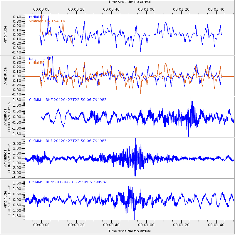
SMM Simmler, CA, USA - Earthquake Result Viewer
*The percent match for this event was below the threshold and hence no stack was calculated.
| Earthquake location: |
Kuril Islands |
| Earthquake latitude/longitude: |
48.4/154.7 |
| Earthquake time(UTC): |
2012/04/23 (114) 22:40:22 GMT |
| Earthquake Depth: |
31 km |
| Earthquake Magnitude: |
5.6 MW, 5.2 MS, 5.4 MB, 5.7 MW |
| Earthquake Catalog/Contributor: |
WHDF/NEIC |
|
| Network: |
CI Caltech Regional Seismic Network |
| Station: |
SMM Simmler, CA, USA |
| Lat/Lon: |
35.31 N/120.00 W |
| Elevation: |
599 m |
|
| Distance: |
61.7 deg |
| Az: |
67.764 deg |
| Baz: |
311.034 deg |
| Ray Param: |
$rayparam |
*The percent match for this event was below the threshold and hence was not used in the summary stack. |
|
| Radial Match: |
48.302963 % |
| Radial Bump: |
400 |
| Transverse Match: |
48.665005 % |
| Transverse Bump: |
400 |
| SOD ConfigId: |
446234 |
| Insert Time: |
2012-07-21 12:49:51.471 +0000 |
| GWidth: |
2.5 |
| Max Bumps: |
400 |
| Tol: |
0.001 |
|
Signal To Noise
| Channel | StoN | STA | LTA |
| CI:SMM: :BHZ:20120423T22:50:06.79498Z | 1.9171425 | 4.2384724E-7 | 2.210828E-7 |
| CI:SMM: :BHN:20120423T22:50:06.79498Z | 0.78400093 | 1.8667147E-7 | 2.3810108E-7 |
| CI:SMM: :BHE:20120423T22:50:06.79498Z | 0.78697723 | 2.681609E-7 | 3.4074796E-7 |
| Arrivals |
| Ps | |
| PpPs | |
| PsPs/PpSs | |


