You are here: Home > Network List > TA - USArray Transportable Network (new EarthScope stations) Stations List
> Station N23A Red Feather Lakes, CO, USA > Earthquake Result Viewer
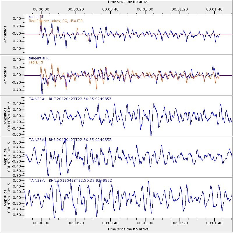
N23A Red Feather Lakes, CO, USA - Earthquake Result Viewer
*The percent match for this event was below the threshold and hence no stack was calculated.
| Earthquake location: |
Kuril Islands |
| Earthquake latitude/longitude: |
48.4/154.7 |
| Earthquake time(UTC): |
2012/04/23 (114) 22:40:22 GMT |
| Earthquake Depth: |
31 km |
| Earthquake Magnitude: |
5.6 MW, 5.2 MS, 5.4 MB, 5.7 MW |
| Earthquake Catalog/Contributor: |
WHDF/NEIC |
|
| Network: |
TA USArray Transportable Network (new EarthScope stations) |
| Station: |
N23A Red Feather Lakes, CO, USA |
| Lat/Lon: |
40.89 N/105.94 W |
| Elevation: |
2458 m |
|
| Distance: |
66.1 deg |
| Az: |
54.881 deg |
| Baz: |
314.02 deg |
| Ray Param: |
$rayparam |
*The percent match for this event was below the threshold and hence was not used in the summary stack. |
|
| Radial Match: |
63.757687 % |
| Radial Bump: |
400 |
| Transverse Match: |
56.940487 % |
| Transverse Bump: |
400 |
| SOD ConfigId: |
446234 |
| Insert Time: |
2012-07-21 12:58:23.917 +0000 |
| GWidth: |
2.5 |
| Max Bumps: |
400 |
| Tol: |
0.001 |
|
Signal To Noise
| Channel | StoN | STA | LTA |
| TA:N23A: :BHZ:20120423T22:50:35.924985Z | 3.8114328 | 4.2370323E-7 | 1.11166386E-7 |
| TA:N23A: :BHN:20120423T22:50:35.924985Z | 0.97732 | 1.5812846E-7 | 1.6179803E-7 |
| TA:N23A: :BHE:20120423T22:50:35.924985Z | 1.3490226 | 1.6017188E-7 | 1.18731805E-7 |
| Arrivals |
| Ps | |
| PpPs | |
| PsPs/PpSs | |


