You are here: Home > Network List > TA - USArray Transportable Network (new EarthScope stations) Stations List
> Station O03D Paynes Creek, CA, USA > Earthquake Result Viewer
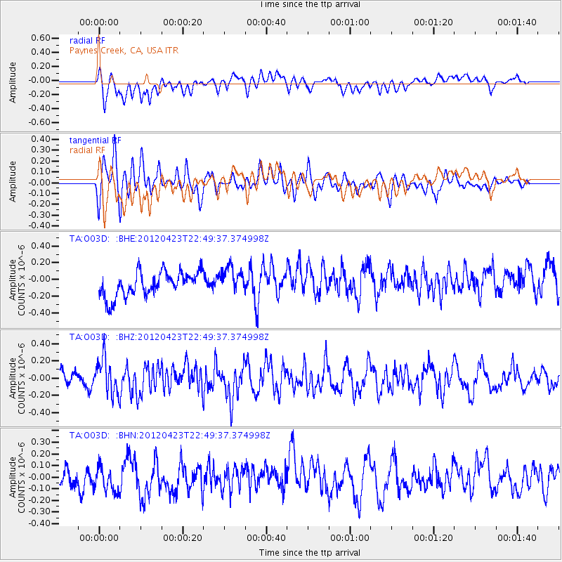
O03D Paynes Creek, CA, USA - Earthquake Result Viewer
*The percent match for this event was below the threshold and hence no stack was calculated.
| Earthquake location: |
Kuril Islands |
| Earthquake latitude/longitude: |
48.4/154.7 |
| Earthquake time(UTC): |
2012/04/23 (114) 22:40:22 GMT |
| Earthquake Depth: |
31 km |
| Earthquake Magnitude: |
5.6 MW, 5.2 MS, 5.4 MB, 5.7 MW |
| Earthquake Catalog/Contributor: |
WHDF/NEIC |
|
| Network: |
TA USArray Transportable Network (new EarthScope stations) |
| Station: |
O03D Paynes Creek, CA, USA |
| Lat/Lon: |
40.29 N/121.80 W |
| Elevation: |
968 m |
|
| Distance: |
57.4 deg |
| Az: |
64.382 deg |
| Baz: |
308.216 deg |
| Ray Param: |
$rayparam |
*The percent match for this event was below the threshold and hence was not used in the summary stack. |
|
| Radial Match: |
49.786865 % |
| Radial Bump: |
400 |
| Transverse Match: |
67.55296 % |
| Transverse Bump: |
400 |
| SOD ConfigId: |
446234 |
| Insert Time: |
2012-07-21 12:59:59.782 +0000 |
| GWidth: |
2.5 |
| Max Bumps: |
400 |
| Tol: |
0.001 |
|
Signal To Noise
| Channel | StoN | STA | LTA |
| TA:O03D: :BHZ:20120423T22:49:37.374998Z | 1.4980658 | 2.0568498E-7 | 1.3730036E-7 |
| TA:O03D: :BHN:20120423T22:49:37.374998Z | 1.105904 | 1.13427184E-7 | 1.0256513E-7 |
| TA:O03D: :BHE:20120423T22:49:37.374998Z | 1.0680884 | 1.5715779E-7 | 1.471393E-7 |
| Arrivals |
| Ps | |
| PpPs | |
| PsPs/PpSs | |


