You are here: Home > Network List > TA - USArray Transportable Network (new EarthScope stations) Stations List
> Station E31A Nome, ND, USA > Earthquake Result Viewer
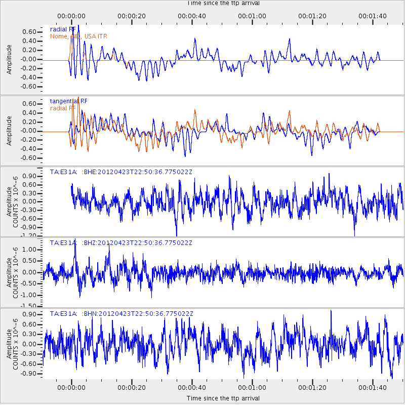
E31A Nome, ND, USA - Earthquake Result Viewer
*The percent match for this event was below the threshold and hence no stack was calculated.
| Earthquake location: |
Kuril Islands |
| Earthquake latitude/longitude: |
48.4/154.7 |
| Earthquake time(UTC): |
2012/04/23 (114) 22:40:22 GMT |
| Earthquake Depth: |
31 km |
| Earthquake Magnitude: |
5.6 MW, 5.2 MS, 5.4 MB, 5.7 MW |
| Earthquake Catalog/Contributor: |
WHDF/NEIC |
|
| Network: |
TA USArray Transportable Network (new EarthScope stations) |
| Station: |
E31A Nome, ND, USA |
| Lat/Lon: |
46.56 N/97.89 W |
| Elevation: |
427 m |
|
| Distance: |
66.3 deg |
| Az: |
46.0 deg |
| Baz: |
315.993 deg |
| Ray Param: |
$rayparam |
*The percent match for this event was below the threshold and hence was not used in the summary stack. |
|
| Radial Match: |
70.81548 % |
| Radial Bump: |
400 |
| Transverse Match: |
54.130074 % |
| Transverse Bump: |
400 |
| SOD ConfigId: |
446234 |
| Insert Time: |
2012-07-21 13:03:51.720 +0000 |
| GWidth: |
2.5 |
| Max Bumps: |
400 |
| Tol: |
0.001 |
|
Signal To Noise
| Channel | StoN | STA | LTA |
| TA:E31A: :BHZ:20120423T22:50:36.775022Z | 2.4456112 | 4.942678E-7 | 2.0210398E-7 |
| TA:E31A: :BHN:20120423T22:50:36.775022Z | 1.1223708 | 3.5771797E-7 | 3.1871636E-7 |
| TA:E31A: :BHE:20120423T22:50:36.775022Z | 1.3865386 | 3.4410937E-7 | 2.4817874E-7 |
| Arrivals |
| Ps | |
| PpPs | |
| PsPs/PpSs | |


