You are here: Home > Network List > TA - USArray Transportable Network (new EarthScope stations) Stations List
> Station D36A Goodland, MN, USA > Earthquake Result Viewer
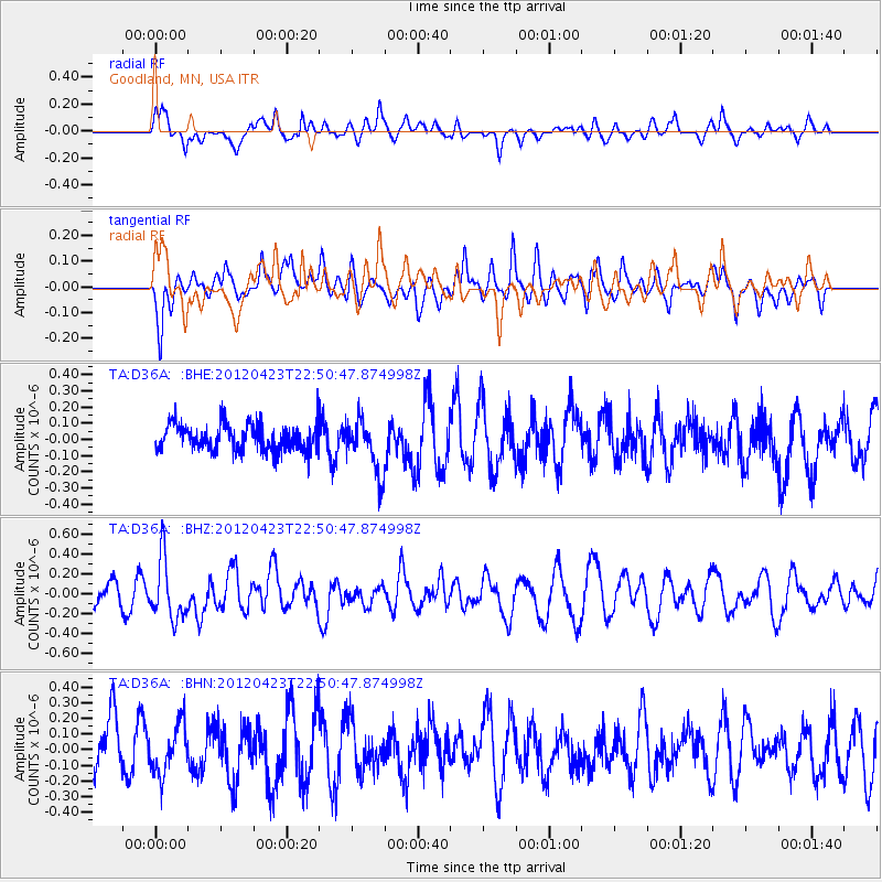
D36A Goodland, MN, USA - Earthquake Result Viewer
*The percent match for this event was below the threshold and hence no stack was calculated.
| Earthquake location: |
Kuril Islands |
| Earthquake latitude/longitude: |
48.4/154.7 |
| Earthquake time(UTC): |
2012/04/23 (114) 22:40:22 GMT |
| Earthquake Depth: |
31 km |
| Earthquake Magnitude: |
5.6 MW, 5.2 MS, 5.4 MB, 5.7 MW |
| Earthquake Catalog/Contributor: |
WHDF/NEIC |
|
| Network: |
TA USArray Transportable Network (new EarthScope stations) |
| Station: |
D36A Goodland, MN, USA |
| Lat/Lon: |
47.18 N/93.16 W |
| Elevation: |
434 m |
|
| Distance: |
68.0 deg |
| Az: |
42.967 deg |
| Baz: |
318.252 deg |
| Ray Param: |
$rayparam |
*The percent match for this event was below the threshold and hence was not used in the summary stack. |
|
| Radial Match: |
42.799053 % |
| Radial Bump: |
383 |
| Transverse Match: |
45.53414 % |
| Transverse Bump: |
390 |
| SOD ConfigId: |
446234 |
| Insert Time: |
2012-07-21 13:05:20.793 +0000 |
| GWidth: |
2.5 |
| Max Bumps: |
400 |
| Tol: |
0.001 |
|
Signal To Noise
| Channel | StoN | STA | LTA |
| TA:D36A: :BHZ:20120423T22:50:47.874998Z | 2.1073823 | 2.986938E-7 | 1.4173688E-7 |
| TA:D36A: :BHN:20120423T22:50:47.874998Z | 0.8774685 | 1.5646962E-7 | 1.7831935E-7 |
| TA:D36A: :BHE:20120423T22:50:47.874998Z | 2.0720346 | 1.6811316E-7 | 8.1134345E-8 |
| Arrivals |
| Ps | |
| PpPs | |
| PsPs/PpSs | |


