You are here: Home > Network List > TA - USArray Transportable Network (new EarthScope stations) Stations List
> Station E36A McGregor, MN, USA > Earthquake Result Viewer
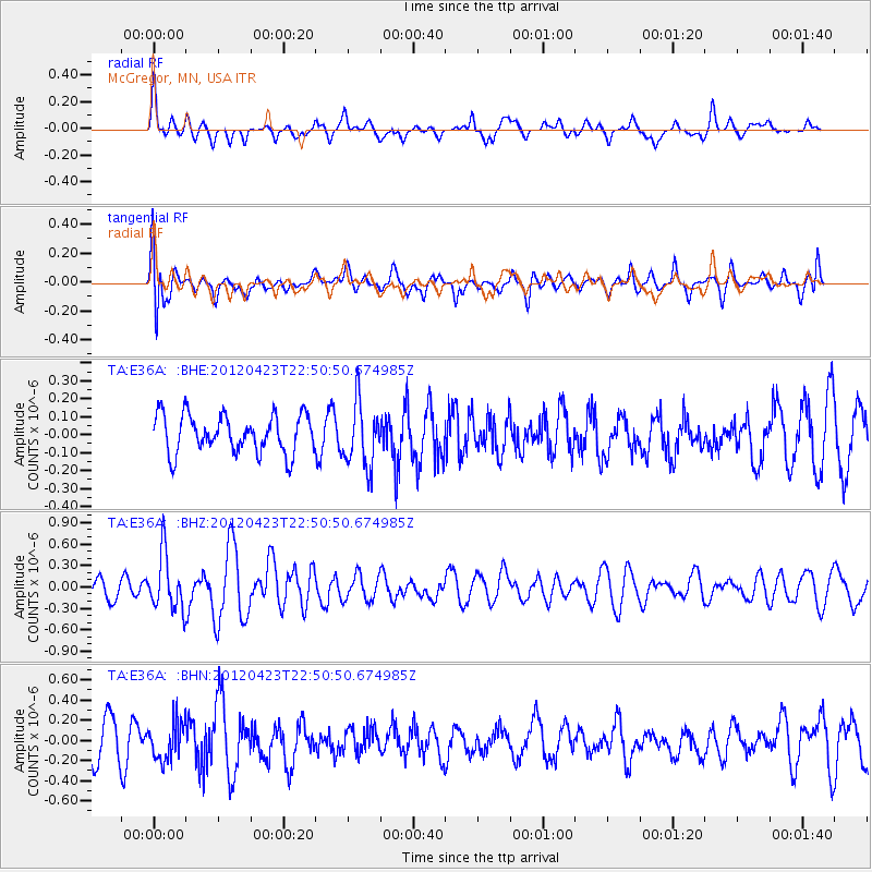
E36A McGregor, MN, USA - Earthquake Result Viewer
*The percent match for this event was below the threshold and hence no stack was calculated.
| Earthquake location: |
Kuril Islands |
| Earthquake latitude/longitude: |
48.4/154.7 |
| Earthquake time(UTC): |
2012/04/23 (114) 22:40:22 GMT |
| Earthquake Depth: |
31 km |
| Earthquake Magnitude: |
5.6 MW, 5.2 MS, 5.4 MB, 5.7 MW |
| Earthquake Catalog/Contributor: |
WHDF/NEIC |
|
| Network: |
TA USArray Transportable Network (new EarthScope stations) |
| Station: |
E36A McGregor, MN, USA |
| Lat/Lon: |
46.52 N/93.26 W |
| Elevation: |
393 m |
|
| Distance: |
68.5 deg |
| Az: |
43.489 deg |
| Baz: |
318.379 deg |
| Ray Param: |
$rayparam |
*The percent match for this event was below the threshold and hence was not used in the summary stack. |
|
| Radial Match: |
58.23789 % |
| Radial Bump: |
400 |
| Transverse Match: |
57.67698 % |
| Transverse Bump: |
400 |
| SOD ConfigId: |
446234 |
| Insert Time: |
2012-07-21 13:07:24.670 +0000 |
| GWidth: |
2.5 |
| Max Bumps: |
400 |
| Tol: |
0.001 |
|
Signal To Noise
| Channel | StoN | STA | LTA |
| TA:E36A: :BHZ:20120423T22:50:50.674985Z | 2.5200326 | 3.9085646E-7 | 1.5509976E-7 |
| TA:E36A: :BHN:20120423T22:50:50.674985Z | 1.1194063 | 1.8815369E-7 | 1.6808346E-7 |
| TA:E36A: :BHE:20120423T22:50:50.674985Z | 1.6969874 | 1.7938044E-7 | 1.0570523E-7 |
| Arrivals |
| Ps | |
| PpPs | |
| PsPs/PpSs | |


