You are here: Home > Network List > G - GEOSCOPE Stations List
> Station KIP Kipapa, Hawai, U.S.A. (Pacific Ocean) > Earthquake Result Viewer
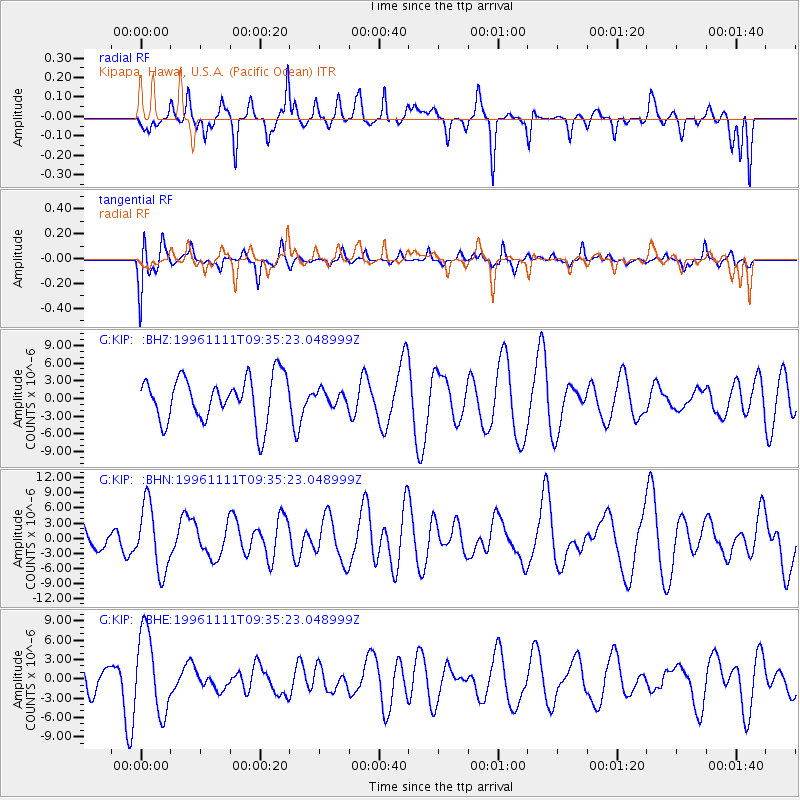
KIP Kipapa, Hawai, U.S.A. (Pacific Ocean) - Earthquake Result Viewer
*The percent match for this event was below the threshold and hence no stack was calculated.
| Earthquake location: |
Myanmar |
| Earthquake latitude/longitude: |
19.3/95.0 |
| Earthquake time(UTC): |
1996/11/11 (316) 09:22:27 GMT |
| Earthquake Depth: |
80 km |
| Earthquake Magnitude: |
5.6 MB, 5.4 MS, 6.0 UNKNOWN, 5.9 MW |
| Earthquake Catalog/Contributor: |
WHDF/NEIC |
|
| Network: |
G GEOSCOPE |
| Station: |
KIP Kipapa, Hawai, U.S.A. (Pacific Ocean) |
| Lat/Lon: |
21.42 N/158.01 W |
| Elevation: |
70 m |
|
| Distance: |
97.9 deg |
| Az: |
64.117 deg |
| Baz: |
294.24 deg |
| Ray Param: |
$rayparam |
*The percent match for this event was below the threshold and hence was not used in the summary stack. |
|
| Radial Match: |
68.84702 % |
| Radial Bump: |
354 |
| Transverse Match: |
49.72812 % |
| Transverse Bump: |
400 |
| SOD ConfigId: |
4480 |
| Insert Time: |
2010-02-26 23:30:37.048 +0000 |
| GWidth: |
2.5 |
| Max Bumps: |
400 |
| Tol: |
0.001 |
|
Signal To Noise
| Channel | StoN | STA | LTA |
| G:KIP: :BHN:19961111T09:35:23.048999Z | 1.1411774 | 6.5466133E-6 | 5.7367183E-6 |
| G:KIP: :BHE:19961111T09:35:23.048999Z | 2.3114166 | 6.319409E-6 | 2.7339981E-6 |
| G:KIP: :BHZ:19961111T09:35:23.048999Z | 0.30821797 | 1.1711012E-6 | 3.7995878E-6 |
| Arrivals |
| Ps | |
| PpPs | |
| PsPs/PpSs | |


