You are here: Home > Network List > TA - USArray Transportable Network (new EarthScope stations) Stations List
> Station S39A Bolivar, MO, USA > Earthquake Result Viewer
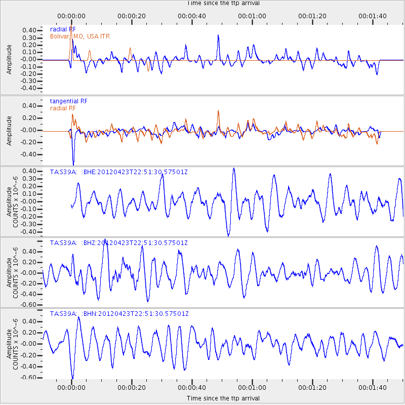
S39A Bolivar, MO, USA - Earthquake Result Viewer
*The percent match for this event was below the threshold and hence no stack was calculated.
| Earthquake location: |
Kuril Islands |
| Earthquake latitude/longitude: |
48.4/154.7 |
| Earthquake time(UTC): |
2012/04/23 (114) 22:40:22 GMT |
| Earthquake Depth: |
31 km |
| Earthquake Magnitude: |
5.6 MW, 5.2 MS, 5.4 MB, 5.7 MW |
| Earthquake Catalog/Contributor: |
WHDF/NEIC |
|
| Network: |
TA USArray Transportable Network (new EarthScope stations) |
| Station: |
S39A Bolivar, MO, USA |
| Lat/Lon: |
37.69 N/93.32 W |
| Elevation: |
331 m |
|
| Distance: |
75.1 deg |
| Az: |
49.579 deg |
| Baz: |
320.24 deg |
| Ray Param: |
$rayparam |
*The percent match for this event was below the threshold and hence was not used in the summary stack. |
|
| Radial Match: |
49.109997 % |
| Radial Bump: |
400 |
| Transverse Match: |
66.827934 % |
| Transverse Bump: |
400 |
| SOD ConfigId: |
446234 |
| Insert Time: |
2012-07-21 13:09:17.822 +0000 |
| GWidth: |
2.5 |
| Max Bumps: |
400 |
| Tol: |
0.001 |
|
Signal To Noise
| Channel | StoN | STA | LTA |
| TA:S39A: :BHZ:20120423T22:51:30.57501Z | 1.1248322 | 2.023315E-7 | 1.7987705E-7 |
| TA:S39A: :BHN:20120423T22:51:30.57501Z | 2.2146082 | 3.283239E-7 | 1.4825372E-7 |
| TA:S39A: :BHE:20120423T22:51:30.57501Z | 1.7508205 | 1.8127392E-7 | 1.0353655E-7 |
| Arrivals |
| Ps | |
| PpPs | |
| PsPs/PpSs | |


