You are here: Home > Network List > TA - USArray Transportable Network (new EarthScope stations) Stations List
> Station N42A Yates City, IL, USA > Earthquake Result Viewer
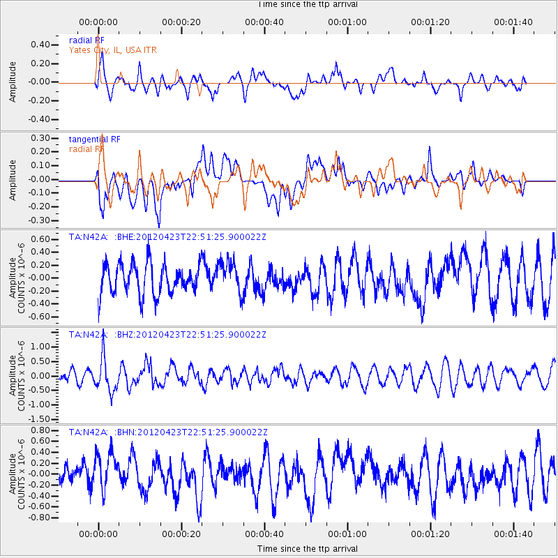
N42A Yates City, IL, USA - Earthquake Result Viewer
*The percent match for this event was below the threshold and hence no stack was calculated.
| Earthquake location: |
Kuril Islands |
| Earthquake latitude/longitude: |
48.4/154.7 |
| Earthquake time(UTC): |
2012/04/23 (114) 22:40:22 GMT |
| Earthquake Depth: |
31 km |
| Earthquake Magnitude: |
5.6 MW, 5.2 MS, 5.4 MB, 5.7 MW |
| Earthquake Catalog/Contributor: |
WHDF/NEIC |
|
| Network: |
TA USArray Transportable Network (new EarthScope stations) |
| Station: |
N42A Yates City, IL, USA |
| Lat/Lon: |
40.83 N/90.03 W |
| Elevation: |
205 m |
|
| Distance: |
74.3 deg |
| Az: |
45.475 deg |
| Baz: |
321.233 deg |
| Ray Param: |
$rayparam |
*The percent match for this event was below the threshold and hence was not used in the summary stack. |
|
| Radial Match: |
56.079403 % |
| Radial Bump: |
400 |
| Transverse Match: |
52.7854 % |
| Transverse Bump: |
400 |
| SOD ConfigId: |
446234 |
| Insert Time: |
2012-07-21 13:15:34.877 +0000 |
| GWidth: |
2.5 |
| Max Bumps: |
400 |
| Tol: |
0.001 |
|
Signal To Noise
| Channel | StoN | STA | LTA |
| TA:N42A: :BHZ:20120423T22:51:25.900022Z | 2.9169385 | 5.881569E-7 | 2.0163502E-7 |
| TA:N42A: :BHN:20120423T22:51:25.900022Z | 1.7674907 | 3.6499486E-7 | 2.0650455E-7 |
| TA:N42A: :BHE:20120423T22:51:25.900022Z | 1.0461767 | 2.473753E-7 | 2.3645654E-7 |
| Arrivals |
| Ps | |
| PpPs | |
| PsPs/PpSs | |


